

Midday Nowcast: Sun, Clouds, Heat, and Tropical Mischief
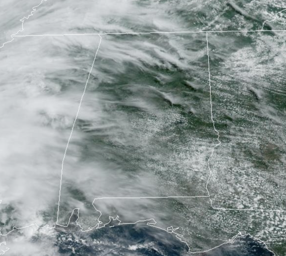
ROUTINE JUNE WEATHER: It is mid-June in Alabama and the weather is fairly routine; the days are featuring a mix of sun and clouds. Rain chances are near zero, but a stray shower or two cannot be ruled out, but don’t expect them as a dry easterly flow is in place across the state. Afternoon highs are ranging from the upper 80s into the lower 90s. The weather will not change through the end of the week, however by Friday, we should see highs climbing into the mid-90s.
BIRMINGHAM ALMANAC: For June 18th, the average high for Birmingham is 89° and the average low is 69°. The record high is 99° set in 1953, while the record low is 56° set in 1960. We average 0.16” of precipitation on this date, and the record value is 1.78” set in 1911.
ACROSS THE USA: Scattered strong to severe thunderstorms capable of producing damaging winds, hail and heavy rainfall will be possible this afternoon over the Upper Mississippi Valley and Central Plains. A low pressure system in the Western Gulf of Mexico will bring heavy to excessive rainfall for much of South Texas. A dangerous heat wave will impact much of the Midwest to the Northeast through this week.
HOT ALABAMA WEEKEND: Heat levels continue to rise with highs in the mid and upper 90s by Saturday and Sunday. Saturday looks dry, but Sunday moisture levels will begin to rise and we will begin to increase the chance for widely scattered afternoon showers and storms.
NEXT WEEK: Moisture levels continue to rise Monday and Tuesday with showers and storms increasing in number, along with lower heat levels. The rest of next week looks to be fairly routine for late June.
IN THE TROPICS: Three areas the National Hurricane Center is monitoring, one of which should become Alberto sooner than later as the NHC is issuing advisories on Potential Tropical Cyclone One and giving it an 80 percent chance of development.
PTC ONE: The disturbance was centered near latitude 21.8 North, longitude 92.7 West. The system is moving toward the north near 7 mph. A turn toward the northwest and west with an increase in forward speed is expected tonight and on Wednesday, and the system is forecast to reach the Gulf coast of Mexico by Wednesday night.
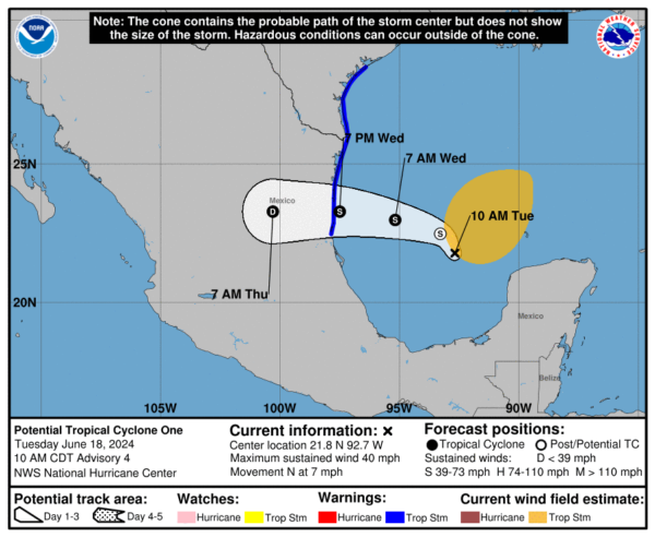
Maximum sustained winds are near 40 mph with higher gusts. Some increase in strength is likely during the next 36 hours, and the disturbance is forecast to become a tropical storm by Wednesday. The disturbance is quite large with tropical-storm-force winds extending outward up to 290 miles north of the center. The estimated minimum central pressure is 999 mb (29.50 inches).
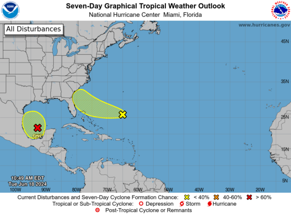
Also in the Atlantic: 1. An area of cloudiness and showers located several hundred miles east of the Bahamas is associated with a surface trough and an upper-level area of low pressure. Environmental conditions could be conducive for some gradual development of this system during the next few days while it moves westward or west-northwestward. The system is forecast to approach the coast of the southeastern United States on Friday. Formation chance through 7 days…low…20 percent.
2. Southwestern Gulf of Mexico: Another broad area of low pressure is forecast to develop over the southwestern Gulf of Mexico this weekend. This is expected to occur after PTC One moves away. Environmental conditions are expected to be conducive for gradual development of this system early next week while it moves slowly northward or northwestward. Formation chance through 7 days…low…20 percent.
BEACH FORECAST CENTER: Dangerous surf conditions with large breaking waves and strong rip currents will continue for the next few days along the Alabama coast and the western Florida panhandle beaches. Some area beaches are reporting double red flags today, meaning the water is closed to the public.
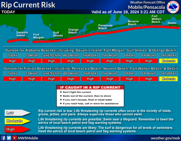
Get the latest weather and rip current forecasts for the beaches from Fort Morgan to Panama City on our Beach Forecast Center page. There, you can select the forecast of the region that you are interested in visiting.
WORLD TEMPERATURE EXTREMES: Over the last 24 hours, the highest observation outside the U.S. was 124.0F at Ahwaz, Iran. The lowest observation was -100.5F at Dome C, Antarctica.
CONTIGUOUS TEMPERATURE EXTREMES: Over the last 24 hours, the highest observation was 114F at Rio Grande Village, TX. The lowest observation was 12F at Mackay, ID.
Category: Alabama's Weather, ALL POSTS
About the Author (Author Profile)
Macon, Georgia Television Chief Meteorologist, Birmingham native, and long time Contributor on AlabamaWX. Stormchaser. I did not choose Weather, it chose Me. College Football Fanatic. @Ryan_StinnetSubscribe
If you enjoyed this article, subscribe to receive more just like it.


