Some Lucky Folks May See a Brief Shower Today or Tomorrow
MAY SQUEEZE A SHOWER OR TWO THIS WEEKEND
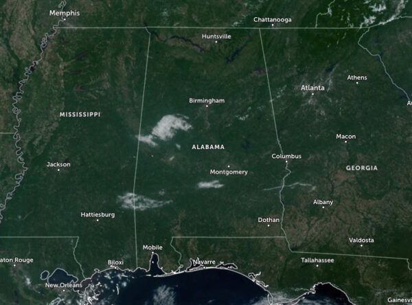
While most people will look up in the sky and see plenty of blue, there are a few clouds drifting over portions of Central Alabama, and we may see a few more form as we head into the afternoon hours. Believe it or not, we do have just enough moisture over the eastern half of the area that a few isolated showers and storms may form with the main heating of the day, but those chances are very slim. One thing we do know for sure is that it will be hot, with highs reaching the mid to upper 90s, and I wouldn’t be surprised if we here of a couple of locations hitting the century mark.
Moisture increases a little more across the area on Sunday, and there is a small chance of isolated to scattered showers and storms during the afternoon and early evening. Slightly higher rain chances will be along and south of I-85. Afternoon highs will once again top out in the mid to upper 90s.
THE WORK WEEK AHEAD
No changes from this morning’s briefing… Ridging will slightly shift eastward on Monday, which will allow for slightly cooler temperatures as we will see an increase in moisture levels and bring a small chance of scattered showers and storms to the west and southwestern parts of Central Alabama. Skies will be partly sunny, with highs in the lower to mid 90s. Tuesday will continue the slight cooldown as some clouds will help to keep those daytime highs away from the triple digits. Skies will be partly sunny, with highs in the upper 80s to the lower 90s.
The ridging breaks down somewhat to end out the work week, as we’ll start to see some impulses move in our direction on Wednesday. However, we’ll stay dry, with highs reaching the upper 80s to the mid 90s underneath partly sunny skies. On Thursday, heat builds off to our west over Mississippi, but we’ll continue with highs in the upper 80s to the mid 90s under sunny skies. Friday looks to be an exact duplicate of Thursday, with sunny skies and highs in the lower to mid 90s.
TROPICAL OUTLOOK
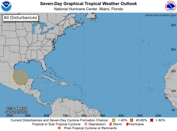
For the North Atlantic, Caribbean Sea, and the Gulf of Mexico: A broad area of low pressure is expected to form over the southwestern Gulf of Mexico early next week. The environmental conditions in this region appear favorable for gradual development, potentially leading to the formation of a tropical depression by the middle of next week. The system is forecast to move slowly westward or west-northwestward.
Regardless of whether the system develops, locally heavy rains are likely to impact portions of southeastern Mexico and Central America over the next several days. The chance of formation through the next 48 hours remains low, near 0 percent, but increases to a medium, 50 percent chance over the next seven days.
ON THIS DAY IN WEATHER HISTORY: 1957
On June 15, one of the most significant and deadly severe weather events in U.S. history occurred in 1957. This event is known as the Fargo Tornado, which was part of the broader tornado outbreak sequence of June 1957. The F5 tornado touched down in the early evening and rapidly intensified. It carved a path of destruction through residential areas of Fargo, causing severe damage to homes and infrastructure. The tornado’s ferocity was evident in the complete obliteration of some structures, leaving only the foundations behind. This tornado had a profound impact on the local community, resulting in significant loss of life and property. 10 people died as a result, along with approximately 103 people injured. The recovery process was long and challenging, with many residents facing the daunting task of rebuilding their lives from scratch.
This tornado is often studied for its intensity and the damage it caused. It serves as a reminder of the destructive potential of severe weather and the importance of preparedness and early warning systems.
SEVERE WEATHER SAFETY
Weather can be unpredictable, catching us off guard with its sudden changes. From thunderstorms to tornadoes or flash floods, being ready beforehand can be a lifesaver. Alabama, with its varied climate, faces its share of severe weather. That’s why having a solid safety plan is so important for everyone. Check out our Severe Weather Safety Guide for valuable tips on how to stay safe when severe weather is on the horizon.
BEACH FORECAST CENTER
Please visit our Beach Forecast Center page to access the most up-to-date weather and rip current forecasts for the beaches spanning from Fort Morgan to Panama City. On this platform, you can choose the forecast specific to the region you intend to visit, ensuring you have accurate and relevant information for your plans.
Category: Alabama's Weather, ALL POSTS, Tropical


