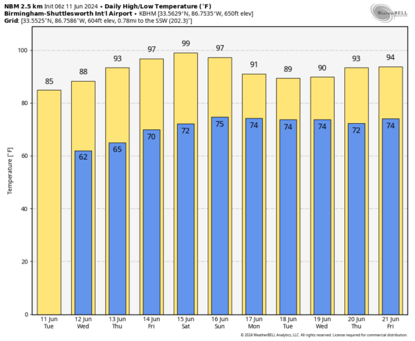
Dry Days Through Saturday; Rising Heat Levels Late In The Week
PLEASANT MORNING: Some North Alabama communities have dipped into the 50s early this morning; most places are in the 60s over the northern 2/3 of the state. With dry air in place, we expect a sunny sky today with a high in the 80s. Tonight will be clear and pleasant again with a low in the 56-64 degree range.
REST OF THE WEEK AND THE WEEKEND: Rising heat levels will headline the forecast with mostly sunny days and fair nights through Saturday. The high tomorrow will be in the 87-91 degree range, followed by mid 90s Thursday, and mid to upper 90s Friday through Sunday. Some spots could flirt with the 100 degree mark; heat index values will be over 100. Easily the hottest weather so far this year.
There will be some increase in moisture Sunday, but for now it looks like any showers will be confined to the southern quarter of Alabama.
NEXT WEEK: We will use the reliable European global model in the forecast, which suggests generally dry weather continuing across the state for much of the week. A few showers are possible Monday and Tuesday, mainly over the southern counties. Heat levels fall with highs close to 90 for the first half of the week, followed by mid 90s Thursday and Friday. See the video briefing for maps, graphics, and more details.
TROPICS: All remains quiet across the Atlantic basin, and tropical storm formation is not expected for at least the next seven days.
ON THIS DATE IN 1990: One of the most expensive hailstorms in U.S. history occurred as $625 million of damage was caused along the Colorado Front Range from Colorado Springs to Estes Park. Golf to baseball sized hail fell along with heavy rain. 60 people were injured in the storm.
Look for the next video briefing here by 3:00 this afternoon… enjoy the day!
Category: Alabama's Weather, ALL POSTS, Weather Xtreme Videos


