Sunday Briefing — A Few Strong/Severe Storms Possible
Today, June 9, 2024:
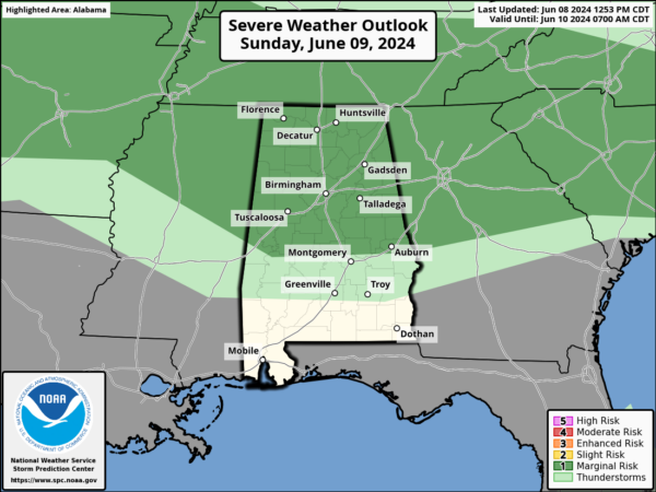
This morning, a disturbance will pass through Tennessee, far northern Alabama, and far northern Georgia. This will bring some isolated showers and thunderstorms, especially near and north of the Interstate 20 corridor. By the afternoon, another disturbance from the Central Plains will move southeast, bringing more showers and storms to our northern and central counties. Expect it to be hot and humid, with increasing dew points creating plenty of instability in the lower atmosphere, making it easier for strong to severe storms to develop. Damaging winds will be the main threat.
A Marginal Risk is up for all of North Alabama and much of Central Alabama to as far south as Livingston, Uniontown, Prattville, and just north of Phenix City. High temperatures will vary: around or just below 90°F in the far north and higher elevations, and up to the mid-90s in the south, west, and central areas. Keep an eye on the weather updates and be prepared to take action if needed. Stay safe, everyone, and keep an eye on the sky!
Monday, June 10, 2024:
On Monday, expect partly to mostly sunny skies. There will be a chance of a few isolated to scattered showers during the morning and early afternoon, but the evening hours will remain dry. High temperatures will range from the lower 80s to the lower 90s across the region.
Tuesday, June 11, 2024:
Tuesday will feature mainly sunny skies with lower humidity levels, providing a pleasant day with no rain expected. High temperatures will range from the lower 80s to the lower 90s.
Wednesday, June 12, 2024:
On Wednesday, there is some model disagreement regarding rain chances. The GFS model suggests dry conditions, while other models indicate a small chance of isolated afternoon showers and storms. Expect partly to mostly sunny skies, with high temperatures ranging from the mid 80s to the lower 90s.
Thursday, June 13, 2024:
Thursday’s forecast also shows some model disagreement. The GFS model keeps us dry, but other models predict rain. A low pressure system over the Gulf of Mexico will send moisture-rich air and scattered showers and storms toward our area. North Alabama may stay dry, while the rest of the state will see rain chances. No severe weather is expected. High temperatures will range from the upper 80s to the lower 90s.
Friday, June 14, 2024:
Friday will be similar to Thursday, with the GFS model predicting dry conditions and other models suggesting scattered showers and storms. The low pressure system will continue to keep the area muggy and send more scattered showers and storms over the region. North Alabama may stay dry, while the rest of the state will see rain chances. No severe weather is expected. High temperatures will range from the mid 80s to the lower 90s.
Saturday, June 15, 2024:
Saturday will see rain chances spread across North and Central Alabama, with those chances increasing as you move south. The GFS model still predicts dry conditions, while other models disagree. Expect partly to mostly cloudy skies, with no severe weather expected. High temperatures will range from the mid 80s to the lower 90s.
Tropical Update (June 9-15, 2024):
While we look to have that low over the Gulf after midweek, it looks like it will not develop any tropical characteristics for now. No tropical developments are expected for the next seven days over the Gulf of Mexico, Caribbean Sea, and the Atlantic Ocean.
Category: Alabama's Weather, ALL POSTS, Severe Weather, Tropical, Weather Xtreme Videos


