Dry Air Pushes Into Alabama Later Today
RADAR CHECK: We have a band of showers and thunderstorms early this morning in areas east and south of Birmingham, the rest of the state is dry with temperatures in the 70s. A cold front will push into the state later today, and by afternoon most of the scattered showers and storms will be over the southern half of the state. With a mix of sun and clouds we expect a high in the upper 80s for most communities today.
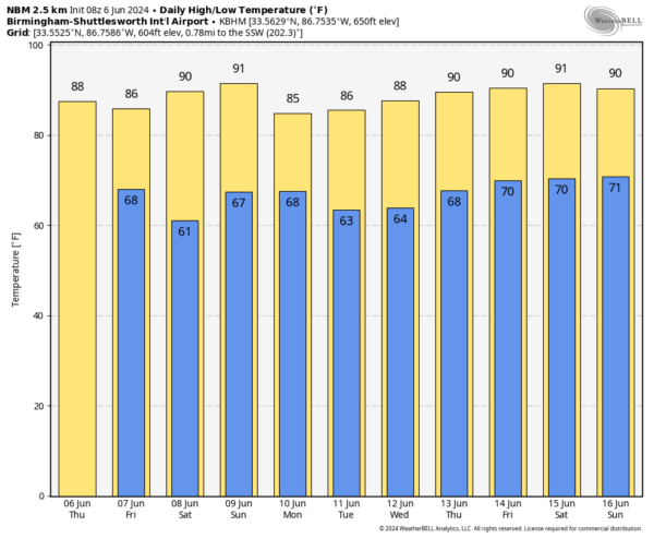
TOMORROW AND THE WEEKEND: A dry, continental airmass will be in place, and we expect rain-free weather tomorrow and Saturday with sunny warm days and clear pleasant nights. Some of the cooler spots could dip into the 50s early Saturday morning over North Alabama. But keep in mind dry air heats very effectively; the high Saturday afternoon will be near 90. But, humidity levels will be low for summer.
Much of the state will stay dry Sunday, but another front will bring a chance of showers or storms by afternoon over the northern third of the state, and there will be a risk of some rain statewide Sunday night as the front drops southward. The high Sunday will also be close to 90 degrees.
NEXT WEEK: Scattered showers Monday will likely be limited to the southern third of the state as the front keeps dropping southward, and almost all of Alabama will experience rain-free weather Tuesday through Thursday. A few scattered showers or storms are possible by Friday; highs will be in the 85-90 degree range through the week. See the video briefing for maps, graphics, and more details.
TROPICS: The Atlantic basin remains quiet and tropical storm formation is not expected for the next seven days.
ON THIS DATE IN 1816: The temperature reached 92 degrees at Salem, Massachusetts during an early heat wave, but then plunged 49 degrees in 24 hours to commence the famous “year without a summer.” Snow fell near Quebec City, Quebec Canada from the 6th through the 10th and accumulated up to a foot with “drifts reaching the axle trees of carriages.”
ON THIS DATE IN 1944: A strong system approaching Europe on June 4, 1944, ended up delaying the original invasion of northern France on June 5. There were even disagreements in the forecast between American and British forecasters. Ultimately, Group Capt, James Stagg of the United Kingdom’s Supreme Headquarters, Allied Expeditionary Force, was the one who persuaded General Dwight D. Eisenhower to change the date of the invasion to June 6 based on weather observations from a ship in the Atlantic.
Look for the next video briefing here by 3:00 this afternoon… enjoy the day!
Category: Alabama's Weather, ALL POSTS, Weather Xtreme Videos


