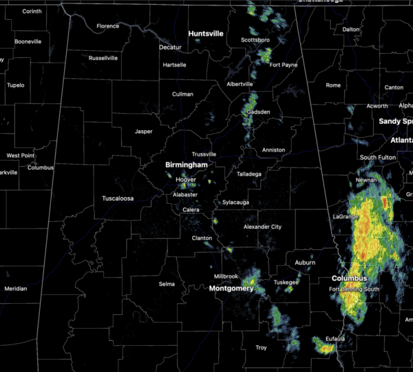
Midday Nowcast: Scattered Showers and Storms this Afternoon
MORE SCATTERED STORMS: A check of the radar late this morning shows a few ongoing showers across Central and East Alabama, but nothing too heavy or widespread. Throughout the rest of today, expect very warm and muggy conditions with highs in the upper 80s and lower 90s. The radar will become more active with showers and storms increasing in coverage. Again, not every location will see rain and storms, but where the storms occur, they will produce gusty winds, hail, and tremendous amounts of lightning. Also, summer time storms are prolific rain producers so be prepared for torrential rainfall which could lead to areas of isolated flash flooding.
BIRMINGHAM ALMANAC: For June 5th, the average high for Birmingham is 86° and the average low is 66°. The record high is 100° set in 1985, while the record low is 47° set in 1946. We average 0.15” of precipitation on this date, and the record value is 3.57” set in 2013.
ACROSS THE USA: Areas of heavy rain and strong winds are ongoing in the Northwest. Showers and severe thunderstorms over parts of the Upper/Middle Mississippi Valley and Central Plains may produce damaging gusts, large hail, and localized areas of flash flooding. A heat wave will impact the southwest U.S. and California Central Valley.
FRONT TOMORROW: A front will drop into the state tomorrow, and the better chance of scattered showers and thunderstorms tomorrow will shift into the eastern and southern counties of the state. Tomorrow will feature a partly sunny sky with highs in the mid to upper 80s.
FRIDAY AND THE WEEKEND: Behind the front, a dry, continental airmass will drop into the Deep South Friday and Saturday; these two days will likely be rain-free across Alabama with lower humidity levels and cooler nights. Highs will be in the 80s; some of the cooler spots could dip into the 50s early Saturday morning. Enjoy the low humidity, because by Sunday, moisture levels rise and we will bring back the chance of scattered showers and thunderstorms.
NEXT WEEK: Low confidence in the forecast next week, but for now we will mention a front will pass through the state Monday with a chance of showers and storms, followed by another shot of dry air Tuesday and Wednesday. Then, scattered showers and storms should return by Thursday and Friday. Highs will be in the 80s through the week.
IN THE TROPICS: For the North Atlantic, Caribbean Sea, and the Gulf of Mexico: Tropical cyclone formation is not expected during the next seven days.
BEACH FORECAST CENTER: Get the latest weather and rip current forecasts for the beaches from Fort Morgan to Panama City on our Beach Forecast Center page. There, you can select the forecast of the region that you are interested in visiting.
WORLD TEMPERATURE EXTREMES: Over the last 24 hours, the highest observation outside the U.S. was 118.8F at Bilma, Niger. The lowest observation was -94.0F at Concordia, Antarctica.
CONTIGUOUS TEMPERATURE EXTREMES: Over the last 24 hours, the highest observation was 114F at Death Valley, CA. The lowest observation was 30F at Synarep, WA.
Category: Alabama's Weather, ALL POSTS


