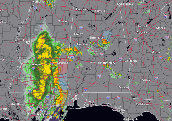
Strong Storms Across Central Alabama
Storms formed late this afternoon as predicted by the convection allowing models, namely the HRRR, in areas south of I-20.
AT this hour, there are four main concentrations of storms.
1. Across northern Sumter into Greene Counties. The storms extend from Geiger to Gainesville to along I-20/59 west of Eutaw. Strongest core is between West Greene to Clinton. These storms are spreading northward Union and Aliceville. Expect gusty winds to 40 mph and pea size hail.
2. Weakening storms are moving across Bibb and southeastern Tuscaloosa County east of Coaling and Brookwood. A developing cell was southwest of Tannehill in northern Bibb County, moving into southwest Jefferson. They could be invigorated by an outflow boundary that is moving northward from Shelby County.
3. Storms near Calera are moving north northeast towards areas from Columbiana to Chelsea. Again, pea sized hail and 40 mph winds are possible. Storms across eastern Shelby County and southwestern Talladega Counties are getting stronger. They extend from Westover to Harpersville to Pleasant Hill affecting areas back to Wilsonville and up to Vandiver, Sterrett and Vincent. Heavy rain, gusty winds, and small hail are possible.
4. A second batch of storms is moving into Montgomery County where a flash flood warning is already in effect. Radar estimates from the first batch of storm indicated 2-2.5 inches of rain fell in some parts of Montgomery a little over an hour ago. Rainfall rains in the approaching storms are nearing 1 inch per hour and could exacerbate any local flooding.
Meanwhile, to the west, a line of strong to severe thunderstorms is approaching the Alabama border from Mississippi. The HRRR indicates these storms will reach west and northwest Alabama between 9-10 pm and they still could be strong to severe. The model also predicts more storms will form ahead of this activity to the south of Birmingham between 10-11 pm.
There still is a severe thunderstorm watch over southeastern Mississippi. No word from SPC about whether a watch will be issued into Alabama, but indications are it isn’t likely. The NWS Birmingham has expanded their marginal risk (level 1/5) to all of their counties whihc includes all of Central Alabama.
Additional storms will form and move east and northeast across Central Alabama between midnight and 6 a.m.
Category: Alabama's Weather, ALL POSTS, Severe Weather


