

Mostly Dry Today; Only Isolated Showers Tomorrow/Friday
COOL START: We actually have some spots over North Alabama in the 50s early this morning… here are some of the cooler observations just before sunrise…
Jasper 55
Fort Payne 55
Morris 56
Cullman 57
Gadsden 57
Pell City 57
Haleyville 57
Anniston 58
Chelsea 58
Oneonta 59
Bessemer 59
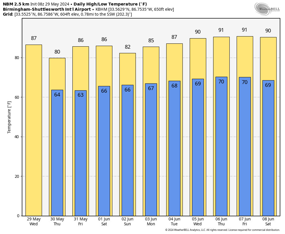
This means the air is dry across Alabama, and showers will be pretty much impossible to find today. With a partly to mostly sunny sky, the high will be in the 85-90 degree range.
TOMORROW/FRIDAY: A few isolated showers can’t be ruled out, but the weather generally stays dry. Tomorrow will be cooler with a high in the 78-83 degree range, then we rise into the mid 80s Friday.
THE WEEKEND: Moisture levels rise, and we will bring in the chance of a few scattered showers and thunderstorms both days. The chance of any one spot getting wet both days is 35-45 percent, and most of the showers will come during the afternoon and evening hours. Very typical weather for early June in Alabama; there will be a mix of sun and clouds both days with highs in the mid 80s.
NEXT WEEK: No real change as the classic summer pattern continues. Partly sunny days with “scattered, mostly afternoon and evening showers and thunderstorms” on a daily basis. Highs mostly in the 80s, although we will be close to 90 by Thursday and Friday. See the video briefing for maps, graphics, and more details.
TROPICS: The Atlantic basin is quiet; tropical storm formation is not expected for the next seven days. The Atlantic basin hurricane season begins Saturday.
NWS SURVEY RESULTS: Most of the damage in Alabama early yesterday morning was the result of straight line winds, but two brief EF-1 tornado tracks were identified. One in Cherokee County north of Weiss Lake, and one in northern Randolph County near Newell.
ON THIS DATE IN 1982: Two significant tornadoes ripped through southern Illinois. The most severe was an F4 that touched down northeast of Carbondale, Illinois then moved to Marion. The twister had multiple vortices within the main funnel. Extensive damage occurred at the Marion Airport. A total of 10 people were killed, and 181 were injured.
Look for the next video briefing here by 3:00 this afternoon… enjoy the day!
Category: Alabama's Weather, ALL POSTS, Weather Xtreme Videos
About the Author (Author Profile)
James Spann is one of the most recognized and trusted television meteorologists in the industry. He holds the AMS CCM designation and television seals from the AMS and NWA. He is a past winner of the Broadcast Meteorologist of the Year from both professional organizations.Subscribe
If you enjoyed this article, subscribe to receive more just like it.


