Uh Oh… Tropics Are Getting a Little Early Start
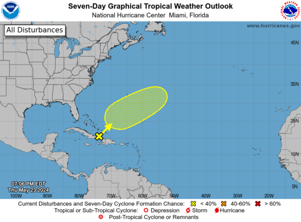
In the southwestern Atlantic, a trough of low pressure is currently causing a widespread area of disorganized cloudiness and showers. This disturbance is expected to give rise to an area of low pressure located approximately halfway between Bermuda and Hispaniola by Friday. Despite the less-than-ideal environmental conditions, there exists a slight possibility of some subtropical or tropical development over the next few days as the system tracks northeastward. The chance of formation within the next 48 hours stands at a low 10 percent, with a similar low probability of 10 percent over the next 7 days. It is advisable to stay informed through local authorities and weather updates to monitor any potential developments in this region.
The National Weather Service’s forecast for the 2024 Atlantic hurricane season predicts an active period with the potential for several named storms and hurricanes. The experts at the National Weather Service anticipate above-average storm activity, indicating an increased likelihood of tropical disturbances forming in the Atlantic Ocean. This forecast suggests that communities along the Atlantic coast and in the Gulf of Mexico should remain vigilant and prepared for possible storm impacts throughout the season. Residents in hurricane-prone areas are advised to have a plan in place, including emergency supplies and evacuation routes, to ensure their safety in the event of a tropical storm or hurricane. Stay tuned to official updates from the National Weather Service and local authorities to stay informed about any developing weather systems and potential threats during the 2024 Atlantic hurricane season.


