Midday Nowcast: Rain and Storms at Times through Tomorrow
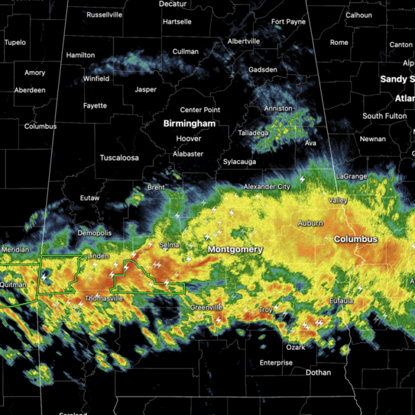
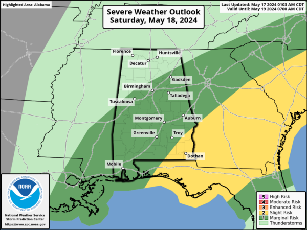
WET AND STORMY FORECAST: Large areas of rain and storms continue to move through the state today, including stronger thunderstorms across the southern third of the state. For now, the more intense activity is over the southern half of the state. For the rest of today, tonight, and through tomorrow, rain and storms will remain in the forecast for Alabama.
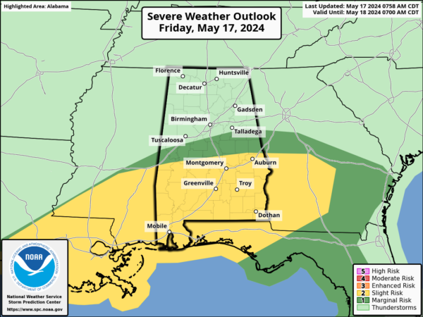
There remains a threat of severe storms both today and tomorrow for Alabama, but again, the better chance of severe storms will be across southern portions of the state as instability values will be very limited today over the northern half of the state, but storms over South Alabama could produce some hail and strong, gusty winds. An isolated tornado or two is possible.
Despite the wet pattern, it is important to note there will be some good breaks in the rain through tomorrow night. There are many outdoor events (graduations, baseball/softball tournaments, the Hangout Music Festival at Gulf Shores, etc) going on; just understand that a shower or storm is possible at any hour of the day or night during the next 48 hours. “When thunder roars; go indoors”… when you hear thunder get inside or in a vehicle.
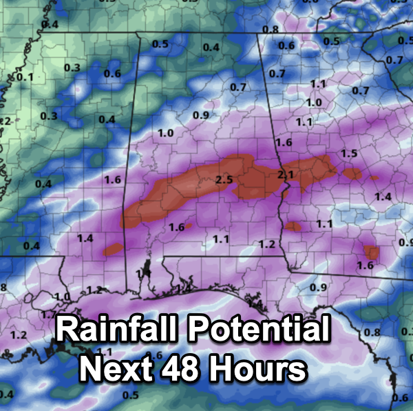
Forecast rain amounts have come down; most places will see rain amounts in the 1-2 inch range through tomorrow night. Across the southern portions of the state, there will be areas of higher amounts, especially where storms are training. We note there is a flash flood watch in effect for the southwest part of the state.
Most of the day Sunday will be dry with a partly sunny sky; just a small risk of a morning shower as an upper trough passes overhead. The high Sunday will be in the mid 80s.
BIRMINGHAM ALMANAC: For May 16th, the average high for Birmingham is 85° and the average low is 61°. The record high is 95° set in 1962, while the record low is 43° set in 1956. We average 0.16” of precipitation on this date, and the record value is 2.69” set in 1930.
NEXT WEEK: An upper ridge will build over the region, and for now a decent part of next week looks dry with highs in the mid to upper 80s and more and more 90s will start to show up on the maps. Though most of the week looks dry, a few scattered showers will be possible, Wednesday and then again late in the week.
BEACH FORECAST CENTER: Get the latest weather and rip current forecasts for the beaches from Fort Morgan to Panama City on our Beach Forecast Center page. There, you can select the forecast of the region that you are interested in visiting.
WORLD TEMPERATURE EXTREMES: Over the last 24 hours, the highest observation outside the U.S. was 117.3F at Jacobabad, Pakistan. The lowest observation was -98.3F at Dome C, Antarctica.
CONTIGUOUS TEMPERATURE EXTREMES: Over the last 24 hours, the highest observation was 110F at Death Valley, CA. The lowest observation was 28F at Peter Sinks, UT.
Category: Alabama's Weather, ALL POSTS
About the Author (Author Profile)
Macon, Georgia Television Chief Meteorologist, Birmingham native, and long time Contributor on AlabamaWX. Stormchaser. I did not choose Weather, it chose Me. College Football Fanatic. @Ryan_StinnetSubscribe
If you enjoyed this article, subscribe to receive more just like it.


