A Late Sunday Evening Look at the Potential for Severe Weather Over the Next Two Days
Parts of Alabama are poised for active weather over the next two days as a storm system moves through the region from Monday into Tuesday. The weather scenario unfolds with severe thunderstorms expected across a large area, extending from central and east Texas to the Gulf Coast states, as a shortwave trough progresses eastward from the central and southern Plains into the Middle to Lower Mississippi Valley. This development will influence weather patterns over Alabama, bringing a combination of damaging winds and hail, and the possibility of a tornado or two.
The atmospheric setup includes midlevel winds ranging from 50-60 knots, with stronger upper-level flows of 70-90 knots shifting northeastward, enhancing the deep-layer shear necessary for severe storm development. At the surface, a weak low-pressure trough will extend southward from northern Missouri through the ArkLaTex into southern Texas, supporting the northward transport of a very moist air mass into Alabama. This moisture, coupled with instability across the region, will foster widespread cloud coverage and precipitation, complicating the forecast and storm tracking.
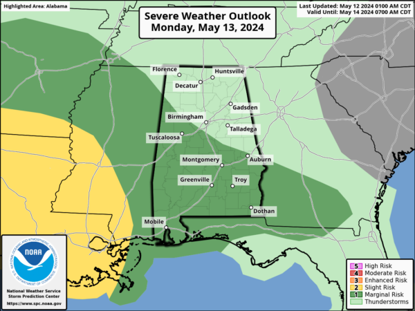
A round of showers and embedded thunder will enter West Alabama around 3-4 a.m. They will not be severe, but will continue through the morning.
Stronger storms will enter Southwest Alabama around 8-10 a.m. and will progress east southeastward, exiting South Alabama around 2-3 p.m. The peak time for severe weather will be during the morning hours between 8-10 a.m.
A second round will enter Southwest Alabama Monday evening and progress across the state during the overnight hours. weakening as they go. They will be strongest over the extreme Southwest, including Mobile, Baldwin, Washington, and Clarke Counties.
Day Two Severe Weather Outlook for Monday:
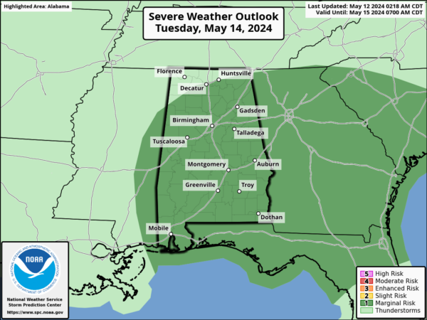
Looking ahead to Tuesday, the focus shifts to isolated severe thunderstorm potential across North and Central Alabama. The movement of a southern-stream shortwave trough across the region will maintain enhanced westerly flow aloft and strong deep-layer vertical shear. While showers and thunderstorms from the previous night might continue into Tuesday morning, there’s a possibility for these storms to regain strength as they encounter a destabilizing airmass later in the day, particularly to the east of Alabama. In Alabama, the uncertainty revolves around whether the airmass will sufficiently recover ahead of a weak surface trough to support organized and potentially severe storms.
Here is the Day Three Outlook for Tuesday:
The main threats will be damaging winds and possibly hail. There should be little tornado threat Tuesday.
Looking ahead to Wednesday and Thursday, a period of dry and mild weather should prevail. Rain and storms will return early Friday though.
Category: Alabama's Weather, ALL POSTS


