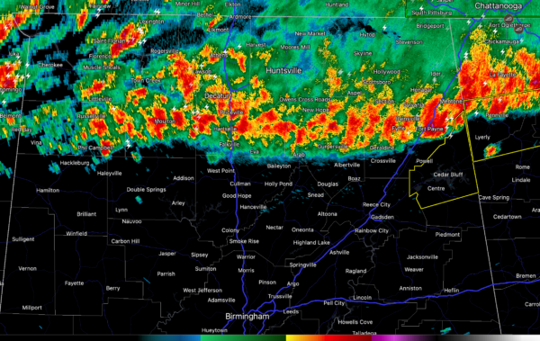
Update on our Storms at 5:55 a.m.
A line of strong storms continues to drop slowly southward across North Alabama this morning.
At 5:55 a.m. CDT, they extended from Phil Campbell in Franklin County to Falkville in Cullman County to Arab in Marshall County to Geraldine to Fort Payne, both in DeKalb County.
They are dropping south at about 25-30 mph.
This will put them into Birmingham before 8 a.m.
The only storms that are severe at this time are over the eastern portion of the line, near a little kink in the echoes. A severe thunderstorm warning is in effect for Cherokee County. 1″ hail and 60 mph winds are possible. A tornado watch is in effect until 10 a.m. CDT, but no signs of rotation at this time in this warned cell.
Most of the lightning is on that eastern cell. There is scattered lightning else along the leading edge of the storms.
The storms may grow stronger through the day as they move southward. The best chances for strong winds and perhaps hail or or tornado will exist south of a line from Reform to Birmingham to Oxford.
Category: Alabama's Weather, ALL POSTS, Severe Weather


