All Quiet for Now…But That Will Change
Everything has been quiet across Alabama since that second tornadic supercell moved out of DeKalb County into Georgia.
Tornado watches that covered much of southern Tennessee, northwestern Mississippi, and eastern Arkansas have expired. So have the ones that were in effect for eastern Tennessee and northern Georgia. At this hour, there are no watches for any part of the U.S., but that will likely change.
The only warning in Alabama is a flash flood warning for parts of Jackson and DeKalb Counties.
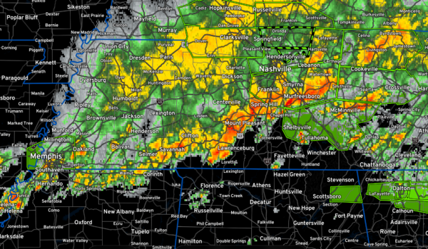
A line of storms extends from Little Rock to Memphis to Nashville to Cookeville in Tennessee. Other strong storms are over northeastern Georgia. The line of storms is ahead of a cold front back over eastern Arkansas and Missouri at this hour. The line of storms will continue to sink east southeastward into North Alabama in the 3-5 a.m. time frame, and will progress southward during the morning. A few storms may break out ahead of the line over the next couple of hours and that will pose a concern. In fact, they appear to be forming now over parts of Colbert and Lauderdale Counties southwest of the Shoals.
Other storms will form around 4-5 a.m. further south, in or south of the I-20 corridor. Those storms pose a tornado risk, as well as a damaging wind risk.
The activity is expected to increase over the northern half of the state between 6-10 a.m., and push mainly east of I-65 by 10 a.m. The activity should be out of Central Alabama by 3 p.m.
The airmass over North and Central Alabama is still unstable with 1,500-2,000 joules per kilogram of CAPE. There is about 40-50 knots of bulk shear to provide storm organization. 0-1km helicity values are near 250-300 m2/s2 over the Tennessee Valley, which is more than sufficient for tornadoes. Those helicity values decrease the further south you go, but they still could support a tornado or two into Central Alabama during the morning.
A new tornado watch or extension of the current watch will be needed shortly as the current one to our north expires at 3 a.m. CDT.
Category: Alabama's Weather, ALL POSTS, Severe Weather


