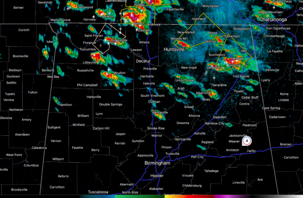
Alabama Weather Update at 7:35 pm
Scattered strong to severe thunderstorms have formed across the northern third of Alabama this afternoon. The strongest storm is south of Dutton in southern Jackson County. This storm will move toward Henagar in DeKalb County.
The storm near Huntsville just prompted a severe thunderstorm warning for parts of Jackson, Madison counties in Alabama, and Franklin County, TN.
The National Weather Service in Huntsville Alabama has issued a
* Severe Thunderstorm Warning for…
Northwestern Jackson County in northeastern Alabama…
Northeastern Madison County in north central Alabama…
Southwestern Franklin County in Middle Tennessee…
* Until 815 PM CDT.
* At 730 PM CDT, a severe thunderstorm was located near Alabama A And
M University, or near Moores Mill, moving northeast at 35 mph.
HAZARD…60 mph wind gusts and quarter size hail.
SOURCE…Radar indicated.
IMPACT…Hail damage to vehicles is expected. Expect wind damage
to roofs, siding, and trees.
* Locations impacted include…
Northern Huntsville, Moores Mill, Huntland, Skyline, Alabama A And
M University, New Market, Hytop, Maysville, Princeton, and Jericho.
Other intensifying storms are over parts of Lauderdale, Colbert, and Lawrence Counties in Northwest Alabama. One storm is near Rogersville, and another is approaching Leighton and Town Creek.
A destructive tornado struck Maury County, Tennessee earlier this afternoon, affecting areas east of Columbia. There was structural damage with people trapped.
Storms will continue to form and intensify during the evening with a line of storms sweeping through the area in the pre-dawn hours.
All forms of severe weather are possible including damaging winds, hail, and a few tornadoes. A tornado watch is in effect for the northern third of Alabama until 11 p.m. It will almost certainly be extended through the evening.
Category: Alabama's Weather, ALL POSTS, Severe Weather


