Cool, Breezy Day For Alabama With A Few Showers
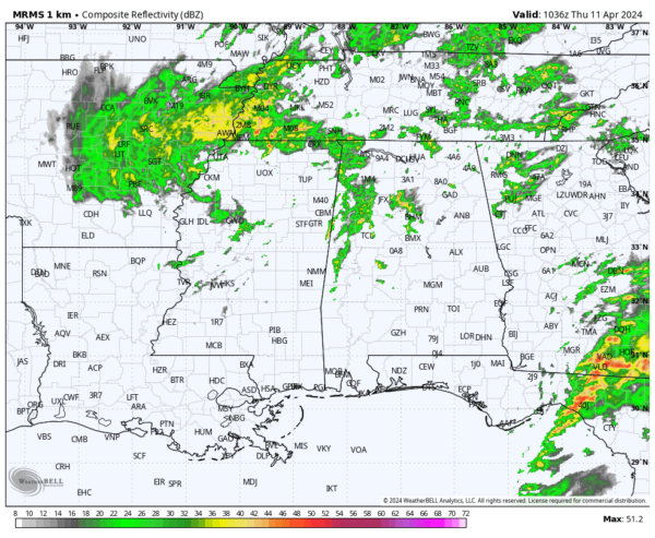
RADAR CHECK: Scattered showers are over the northern 2/3 of Alabama early this morning ahead of an upper trough. Today will be mostly cloudy, breezy, and cool with showers possible. Nothing too heavy or widespread, and most of the rain will remain over the northern and central counties. Best chance of seeing some sun today is near the Gulf Coast; highs will be in the 68-72 degree range.
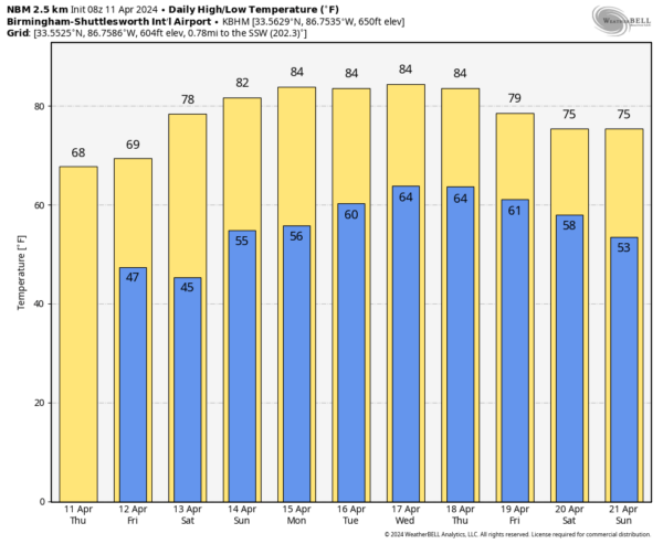
TOMORROW AND THE WEEKEND: Dry weather is the story with sunny days and fair nights. Lows will be in the 40s early tomorrow and Saturday morning… the high will be near 70 tomorrow, and close to 80 Saturday. Low 80s are likely Sunday as the warming trend continues.
NEXT WEEK: It will be the warmest week so far this year with highs in the 81-86 degree range through Thursday. A front will bring a few showers to Alabama Thursday night or Friday, but rain amounts should be light, and there is no risk of severe storms. The high Friday will be in the upper 70s. No sign of any high impact weather event for Alabama for the next 10 days; an unusually quiet period for mid-April. See the video briefing for maps, graphics, and more details.
STORM SURVEY: NWS Mobile determined a short lived EF-1 tornado touched down in the Georgetown community (northwest of Mobile) yesterday; it was down for only one minute.
ON THIS DATE IN 1965: Severe thunderstorms in the Upper Midwest spawned fifty-one tornadoes killing over 250 people and causing more than 200 million dollars damage. Indiana, Ohio and Michigan were hardest hit in the “Palm Sunday Tornado Outbreak”. Although no F5’s were officially reported, at least 22 were rated as F3 or F4. This is the third deadliest day for tornadoes on record, behind the Super Outbreak of 4/3/1974, and the outbreak that included the Tri-State Tornado of 3/18/1925.
Dr. Ted Fujita discovered suction vortices during the Palm Sunday tornado outbreak. It had been believed the reason why tornadoes could hit one house and leave another across the street completely unscathed was because the whole tornado would “jump” from one house to another. However, the actual reason is because most of the destruction is caused by suction vortices: small, intense mini-tornadoes within the main tornado.
ON THIS DATE IN 2007: Severe thunderstorms, some with large hail, moved across Alabama. Five tornadoes touched down, all rated EF-0 or EF-1, including one near Bagley in far Northwest Jefferson County.
Loo for the next video briefing here by 3:00 this afternoon… enjoy the day!
Category: Alabama's Weather, ALL POSTS, Weather Xtreme Videos


