Saturday Morning Video Briefing and Details
As we approach the end of March, the lambs have replaced the lions, and relatively calm weather affects Alabama. In the two forecast periods, we will deal with some strong storms on Tuesday and again at the end of the week. But for now, some fine weather is in store for this Easter weekend.
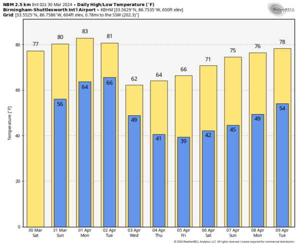
FOR YOUR SATURDAY: Today will be an absolutely gorgeous day across North and Central Alabama, with highs in the middle and upper 70s after morning lows in the 40s. Temperatures tonight will generally be in the 50s as southerly winds bring in warmer and more moist air.
EASTER SUNDAY: Tomorrow will be like today, with a good supply of sunshine and high temperatures ranging from 77F-83F. Lows Sunday night will be in the lower 60s.
BALMY MONDAY: A ridge of high pressure across the southern United States is forecasting more nice weather on Monday. Highs will reach 80F in most areas, with some Central Alabama locations approaching the middle 80s. Monday night lows will be in the lower and middle 60s.
TUESDAY STORMS: On Tuesday, the ridge will weaken enough for a cold front to approach from the northwest. Showers and storms will develop during the day, and there could be enough instability for some storms to be strong to severe. Damaging winds look like the main threat. The greatest threat appears to be during the afternoon hours.
COLD AIR ADVECTION: Behind the system, clearing skies and colder conditions will dominate by Wednesday. Lows Wednesday morning will be in the 40s, with highs topping out in the 60s areawide. Chillier but sunny conditions will prevail for Thursday and Friday, with highs warming through the 60s and lows in the 40s. There could be frost in normally colder North Alabama locations on Thursday and Friday mornings.
WEEKEND OUTLOOK: The weekend looks nice, with a good supply of sunshine on both days, highs in the 70s, and lows in the 40s.
ECLIPSE WATCH: The total eclipse on Monday, April 8th is looking kind of cloudy for our friends in Texas. Arkansas and southern Illinois could fare better, as could Vermont and upstate New York. But will way too much uncertainty at this point in the forecast. Here is Alabama, even though we won’t enjoy totality, our skies area expected to be partly cloudy at worst. Make sure you follow ALL eclipse precautions if you plan to view the spectacle.
BEACHCAST: Showers Tuesday night and early Wednesday, but that is about the only set of rain chances until late in week two. Highs over the next two weeks with be in the 70s most every day, with a wide range of 40s, 50s, and 60s each morning. The rip current risk will be low to moderate through midweek. Water temperatures are in the mid 60s.
Click here to see the Beach Forecast Center page.
ADVERTISE WITH US: Deliver your message to a highly engaged audience by advertising on the AlabamaWX.com website. We have a lot of big plans for this year. Don’t miss out! We can customize a creative, flexible, and affordable package that will suit your organization’s needs. Contact me, Bill Murray, at (205) 687-0782 and let’s talk.
WEATHERBRAINS: This week, the panel will remember the 1974 Superoutbreak of tornadoes. Check out the show at www.WeatherBrains.com. You can also subscribe on iTunes. You can watch the show live on our new YouTube channel for the show.You will be able to see the show on the James Spann 24×7 weather channel on cable or directly over the air on the dot 2 feed.
ON THIS DATE IN 1962: An approaching cold front brought a round of strong storms to North and Central Alabama. More about the event in a special AlabamaWX blog post. Follow my weather history tweets on Twitter. I am @wxhistorian at Twitter.com.
Category: Alabama's Weather, ALL POSTS, Severe Weather


