Low 80s Possible Today; Strong Storms Arrive Tomorrow
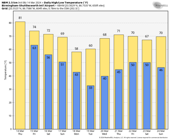
WARMEST SO FAR: We are projecting a high in the 78-83 degree range across Alabama today, for many places it will be warmest day so far this year. The last time Birmingham had high of 80 or higher was on November 8, when the high was 81. Look for a mix of sun and clouds, and most places will be dry.
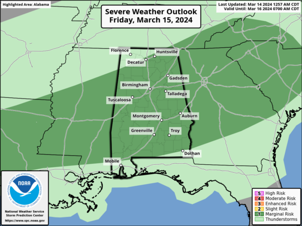
RAIN RETURNS: A band of showers and strong storms will push into Alabama after midnight tonight, and during the day tomorrow. Much of the state is in a “marginal risk” (level 1/5) of severe thunderstorms as defined by the Storm Prediction Center (SPC).
Storms will likely enter the northwest corner of the state around 3-4 a.m…. then dropping southward during the day tomorrow. The storms will be capable of producing strong winds and some hail; there is basically no tornado threat based on the forecast wind profiles. By mid-afternoon most of the rain will be over the southern half of the state. So, it won’t rain all day, and the high will be in the 70s.
THE ALABAMA WEEKEND: Most of the state will be dry Saturday, but showers are possible over the far southern counties. The sun could peek out at times, and the high will be in the low 70s. Sunday will be be a cloudy day with a chance of showers, but nothing too heavy or widespread. The high Sunday afternoon will be between 66 and 73 degrees.
NEXT WEEK: The weather will be dry during the first half of the week, and sharply colder. Another late season freeze is likely over the northern half of the state early Tuesday morning, with lows in the 25-35 degree range. Some frost is possible across South Alabama.
Rain will likely return to the Deep South Thursday night and Friday; for now it doesn’t look like a severe thunderstorm situation. See the video briefing for maps, graphics, and more details.
ON THIS DATE IN 2008: The SEC basketball tournament was underway in Atlanta, and Alabama/Mississippi State was in overtime when a loud roaring sound was heard. Television announcers said that it sounded like a freight train. Lights and catwalks in the Dome began to sway and debris rained down inside the arena. Players on the court stopped and fans in the upper levels of the arena began to panic. No one knew what was going on. There were no public address announcements about the severe weather outside until well after the storm had hit.
The court was cleared and order restored, but outside, the scene was like that of a war zone. Damage was widespread. An F2 tornado had struck downtown Atlanta. The tornado damaged not only the Georgia Dome, Philips Arena, the CNN Center, and the Omni Hotel, but it blew windows out of downtown hotels, cars, and buildings and even caused the collapse of several buildings. In the nearby historic Cabbagetown district, several homes and buildings were destroyed. Over fifty homes were destroyed and the Cotton Mill lofts were heavily damaged. Tragically, one person was killed in the tornado in a collapsed building. Thirty were injured in the tornado.
ON THIS DATE IN 2019: A total of 15 tornadoes touched down across Alabama. The strongest was an EF-2 that moved through rural parts of Elmore County, north of Wetumpka.
Look for the next video briefing here by 3:00 this afternoon… enjoy the day!
Category: Alabama's Weather, ALL POSTS, Weather Xtreme Videos


