Drier Air Moves Into Alabama Tonight; A Little Cooler Tomorrow
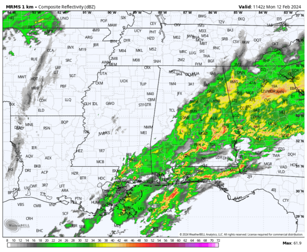
RADAR CHECK: A large mass of rain with a few embedded thunderstorms continues to cover much of Alabama early this morning. Flash flood warnings are in effect for parts of Montgomery, Macon, Bullock, and Lee counties, where over three inches of rain has been measured over the past 24 hours.
A tornado watch is in effect for South Alabama until 9:00 a.m… but there hasn’t been a single severe weather report overnight, and the overall risk of a severe thunderstorm is low for the next few hours.
There will be a risk of a few severe thunderstorms later this morning into the early afternoon hours over Southeast Alabama (places like Dothan, Ozark, Geneva, Enterprise, etc)… the main threat will come from strong gusty winds, although a brief, isolated tornado can’t be totally ruled out. The air is rain cooled and stable over the rest of the state, and severe storms are not expected there. Rain has already ended for now for areas west and north of Birmingham.
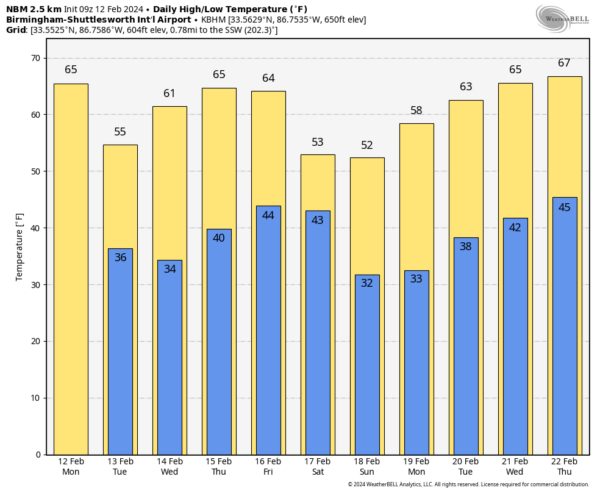
Some partial clearing is possible this afternoon, followed by a narrow band of showers this evening along a cold front. Additional rain this evening will be light, and the showers should be out of the state by midnight. Expect a high in the 60s today.
REST OF THE WEEK: Tomorrow will be sunny and cooler with a high in the 50s for most communities. Dry weather continues Wednesday and Thursday with highs back in the 60s. Then, we will bring in a chance of rain late Friday and Friday night ahead of a cold front. Moisture will be limited, and rain amounts should be 1/2 inch or less. No risk of severe storms.
THE ALABAMA WEEKEND: Rain will end Saturday morning for most of the state, although lingering showers are possible during the afternoon and evening hours near the Gulf Coast. The day will be cooler with a high in the 50s. Then, on Sunday, we expect sunshine in full supply with highs remaining in the 50s. North Alabama communities will likely see a freeze early Sunday morning.
Dry weather continues into the first of the following week with a warming trend. Still no sign of any bitterly cold Arctic air for the Deep South for the next 7-10 days… See the video briefing for maps, graphics, and more details.
ON THIS DATE IN 1899: The bitter cold outbreak of February 1899 continued across the southern Plains, Texas, and the Deep South. The mercury dipped to 8 degrees below zero at Fort Worth, Texas, and 22 degrees below zero at Kansas City, Missouri. Nebraska’s temperature at Camp Clarke plunged to 47 degrees below zero to establish a state record. The all-time record low for Oklahoma City was set when the temperature fell to a frigid 17 degrees below zero, breaking the previous record low of 12 below zero, set on the previous day. Washington D.C. hit 15 degrees below zero, while Charleston, SC, received a record four inches of snow. Snow was also reported in Fort Myers, Tampa, and Tallahassee in Florida.
Birmingham would see a low of -10F on February 13, 1899… still the coldest temperature on record for the city.
ON THIS DATE IN 1945: A devastating tornado outbreak occurred across the Southeastern United States. The storms killed 45 people and injured 427 others. One of the tornadoes moved through Montgomery, killing 26. The Montgomery storm destroyed around 100 houses, as well as two warehouses and a freight train.
ON THIS DATE IN 1958: Snow blanketed northern Florida, with Tallahassee reporting a record 2.8 inches. A ship in the Gulf of Mexico, 25 miles south of Fort Morgan, Alabama, reported zero visibility in heavy snow on the afternoon of the 12th.
Look for the next video briefing here by 3:00 this afternoon… enjoy the day!
Category: Alabama's Weather, ALL POSTS, Weather Xtreme Videos


