
Severe Weather Threat For Later Today and Tonight
Here is the latest SPC Day One outlook for severe weather. It is slightly expanded from yesterday.
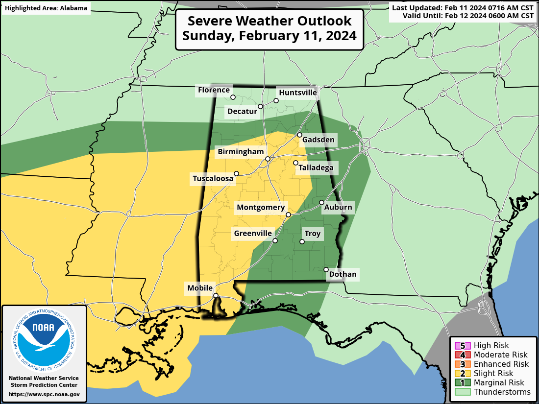
Damaging winds, large hail, and a few tornadoes are possible today in the marginal (1/5) and slight risk (2/5) areas across Alabama and the South. The higher risk for severe weather is of course in the yellow including Birmingham, Tuscaloosa, Talladega, Montgomery, Greenville, and Mobile. The marginal risk covers much of the rest of the state. The Tennessee Valley has no severe weather threat, nor does Southeast Alabama around Dothan.
The rain that moved into Alabama overnight is diminishing as expected. At this hour, showers cover parts of Alabama between I-59 and I-85/65.
This activity will continue to move into Georgia and be gone by 10 a.m. or so.
Additional showers are over Mississippi. There is a heavy thunderstorm north of Jackson approaching Canton, with additional storms back into Northeast Louisiana.
There is a line of storm over eastern Texas extending from Marshall to Allo to Madisonville to east of College Station to LaGrange. Several of them are severe with several indications of 1 inch hail along with damaging winds. These storms are associated with an upper level disturbance that will swing eastward today along with a surface low coming out of the Hill Country and the warm front that will lift northward ahead of it.
Temperatures are in the 50s over North Alabama and 60s south of I-59. Dewpoints > 65F cover South Alabama. This warm, moist air will come northward today ahead of the low.
It looks like the warm front will be lifting northward into Central Alabama around 5-6 pm and storms will be likely across Central Alabama through midnight, slowly weakening after that. Supercell thunderstorms will be part of the mix and damaging winds, hail, and a few tornadoes are possible.
Review your severe weather safety plans, know where you will be and where you will go if a warning is issued later this afternoon and tonight. Have multiple reliable ways of receiving warnings for your location and respect the polygon if one if issued for your location by going to a safe place until teh storm passes.
We will have frequent updates.
Category: Alabama's Weather, ALL POSTS, Severe Weather
About the Author (Author Profile)
Bill Murray is the President of The Weather Factory. He is the site's official weather historian and a weekend forecaster. He also anchors the site's severe weather coverage. Bill Murray is the proud holder of National Weather Association Digital Seal #0001 @wxhistorianSubscribe
If you enjoyed this article, subscribe to receive more just like it.


