Sunday Morning Video Briefing: A Cold, Rainy, Windy, Miserable Day for Most
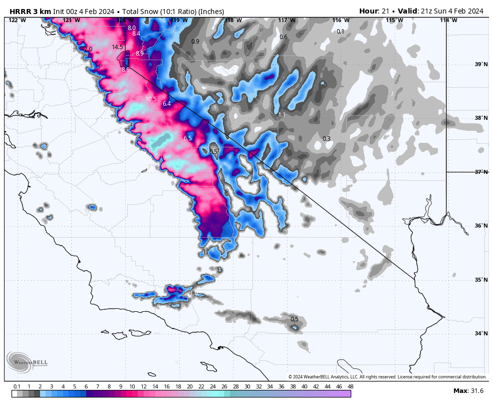
Greetings from the AMTRAK’s train number 5, the westbound California Zephyr. I departed Salt Lake City late Saturday evening enroute to Sacramento, California, over Donner Pass, which should be fantastic today in heavy snow and wind. Donner Pass is at 7,056 feet. This is the official NWS forecast:
.SUNDAY…Heavy snow showers. Snow accumulation of 10 to
18 inches with 16 to 24 inches above 7000 feet. Highs 33 to 38.
Southeast winds 10 to 15 mph. Gusts up to 30 mph in the
afternoon. Ridge gusts up to 65 mph, increasing to 95 mph in the
afternoon.
The accumulations on Sunday are on top of 2-6 inches that fell last night. Winter storm warnings are in effect through Monday morning.
Fingers crossed that the Southern Pacific doesn’t close the route over Donner Pass and cancel the train!
ON THE WEATHER MAPS THIS MORNING: Strong high pressure over North Carolina pushed a backdoor cold front into eastern Alabama on Saturday. It lies from about Vernon in Lamar County to near Troy over South Central Alabama. Meanwhile, twin low pressure centers over the northern Gulf of Mexico, one near southeastern Louisiana and another south of Destin are revving up and will effectively lift widespread moisture over the frontal boundary, producing rainfall over much of Alabama today. Rainfall amounts should average about one inch to 1.5 inches in most spots. That shouldn’t cause any problems as it will be fairly gentle and spread over several hours. Highs today will struggle to get out of the 40s over the northeastern, as we run about 20 degrees below normal. There will be quite a temperature gradient over South Alabama with 50F at Montgomery, 56F at Greenville, 60F Evergreen, and 65F at Mobile. Lows tonight will be in the upper 30s in Northwest Alabama and in the lower 40s over Central and South Alabama.
EVERYONE KNOWS ITS WINDY: And those winds will be increasing across Alabama today and the surface lows do their thing over the Gulf. Wind advisories are in effect over Coastal Alabama and Northwest Florida where winds will average 20-30 mph with gusts to 45 mph. Gale warnings are in effect over the Gulf waters.
THIS JUST IN: The NWS in Birmingham has issued a Wind Advisory for Central Alabama for those winds averaging 10-20 mph with occasional gusts to 30-40 mph. It goes through 6 p.m. Sunday.
DROUGHT WATCH: Our short-term lawn and garden water needs are in good shape across all of Alabama. The National Drought Monitor still shows D1 or D2 drought (moderate to severe) over much of the northwestern half of Alabama. About 29% of the rest of the state is still abnormally dry in terms of long term conditions.
THE WORK WEEK: Skies will begin to clear from the northwest Monday, and temperatures that start out in the upper 30s and lower 40s will be fairly uniform in the upper 50s to around 60F. A ridge of high pressure along the East Coast will protect us through Thursday. Lows will be in the lower to upper 30s Tuesday and Wednesday morning, and about 5-6 degrees warmer Thursday morning. Highs will hover in the upper 50s and lower 60s.
FRIDAY FRONT: By late Thursday, the ridge will be breaking down and will allow a front to approach Alabama from the northwest. It will be progressing slowly southeastward, and could stall over Central Alabama late Friday. Rainfall amounts on Friday won’t be very heavy. Waves of low pressure will tend to ripple along the frontal system through the weekend meaning rounds of showers and rain. The rain could keep coming until late Monday. Rainfall amounts look pretty paltry, with a third to one half inch over the northern half of the state and 1-2 inches over South Alabama. There will be some thunder through the period, and we can’t rule out a few strong storms, but the chance of severe weather looks low.
VOODOO COUNTRY: The GFS is pitching a fast hitting system with rain and storms on Friday the 15th and another system following on its heels on Saturday night the 16th. No instability at all with either system, but a cool rain. Week two highs will be in the 50s and 60s, with lows in the 40s and 50s. There does appear to be a significant cold snap coming out by the weekend of the 16th and 17th, with highs in the 40s and lows in the 20s and 30s. There is a high rip current risk through Monday, but moderate into midweek.
BEACHCAST: Wet today, showers Monday, clearing Tuesday and dry weather until a few showers Thursday and Friday, with a little better rain chances Saturday and Sunday. Highs will be in the 50s and 60s through midweek, but trending toward 70F at the end of the week and weekend. Lows will be in the 40s through Thursday morning, with 50s through the weekend. Water temperatures are in the upper 50s.
Click here to see the Beach Forecast Center page.
DANCING WITH THE STATS: No interesting records across the U.S. on Saturday, just some daily precipitation records across the Intermountain West out onto the Plains.
ADVERTISE WITH US: Deliver your message to a highly engaged audience by advertising on the AlabamaWX.com website. The site enjoyed over 29 MILLION page views in the past 12 months. Don’t miss out! We can customize a creative, flexible, and affordable package that will suit your organization’s needs. Contact me, Bill Murray, at (205) 687-0782 and let’s talk.
WEATHERBRAINS: This week, the panel will entertain Mike Gremillion, the Head of the National Water Center in Tuscaloosa. . Check out the show at www.WeatherBrains.com. You can also subscribe on iTunes. You can watch the show live at live.bigbrainsmedia.com or on James’ YouTube Channel You will be able to see the show on the James Spann 24×7 weather channel on cable or directly over the air on the dot 2 feed.
ON THIS DATE IN 2007: Super Bowl XLI was the first wet Super Bowl in history. It rained 0.92 of an inch in Miami, the most there since November 16, 2006. The persistent heavy rain resulted in numerous turnovers during the sloppy game, which was won by Indianapolis. The unfortunate weather followed several days of fine weather, including an 87 degree high just two days before. Follow my weather history tweets on Twitter. I am @wxhistorian at Twitter.com.
Category: Alabama's Weather, ALL POSTS
About the Author (Author Profile)
Bill Murray is the President of The Weather Factory. He is the site's official weather historian and a weekend forecaster. He also anchors the site's severe weather coverage. Bill Murray is the proud holder of National Weather Association Digital Seal #0001 @wxhistorianSubscribe
If you enjoyed this article, subscribe to receive more just like it.


