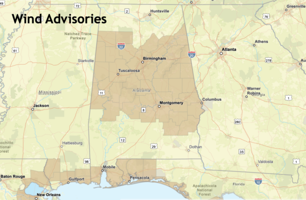
Wind Advisory for Central Alabama
EVERYONE KNOWS ITS WINDY: And those winds will be increasing across Alabama today and the surface lows do their thing over the Gulf. Wind advisories are in effect over South Alabama where winds will average 20-30 mph with gusts to 45 mph. Gale warnings are in effect over the Gulf waters.
URGENT – WEATHER MESSAGE
National Weather Service Birmingham AL
1010 PM CST Sat Feb 3 2024
ALZ011>015-017>050-041400-
/O.NEW.KBMX.WI.Y.0004.240204T0410Z-240205T0000Z/
Marion-Lamar-Fayette-Winston-Walker-Blount-Etowah-Calhoun-
Cherokee-Cleburne-Pickens-Tuscaloosa-Jefferson-Shelby-St. Clair-
Talladega-Clay-Randolph-Sumter-Greene-Hale-Perry-Bibb-Chilton-
Coosa-Tallapoosa-Chambers-Marengo-Dallas-Autauga-Lowndes-Elmore-
Montgomery-Macon-Bullock-Lee-Russell-Pike-Barbour-
Including the cities of Hamilton, Sulligent, Vernon, Fayette,
Double Springs, Jasper, Oneonta, Gadsden, Anniston, Centre,
Heflin, Carrollton, Tuscaloosa, Birmingham, Hoover, Columbiana,
Pelham, Alabaster, Pell City, Moody, Talladega, Sylacauga,
Ashland, Roanoke, Livingston, Eutaw, Greensboro, Moundville,
Marion, Centreville, Clanton, Rockford, Alexander City,
Dadeville, Valley, Lanett, Lafayette, Demopolis, Linden, Selma,
Prattville, Fort Deposit, Hayneville, Wetumpka, Tallassee,
Montgomery, Tuskegee, Union Springs, Auburn, Opelika,
Phenix City, Troy, and Eufaula
1010 PM CST Sat Feb 3 2024
…WIND ADVISORY IN EFFECT UNTIL 6 PM CST SUNDAY…
* WHAT…East to southeast winds 10 to 20 mph with gusts up to 30
to 40 mph possible.
* WHERE…all of central Alabama.
* WHEN…Until 6 PM CST Sunday.
* IMPACTS…Gusty winds could blow around unsecured objects.
Tree limbs could be blown down and a few power outages may
result.
PRECAUTIONARY/PREPAREDNESS ACTIONS…
Use extra caution when driving, especially if operating a high
profile vehicle. Secure outdoor objects.
Category: Alabama's Weather, ALL POSTS


