Wind Advisories, High Wind Watches, and Marine Wind Warnings
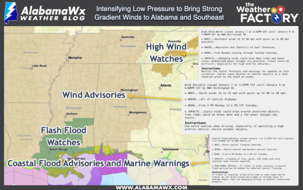
National Weather Service offices across the Southeast have issued wind advisories, high wind watches, and marine wind warnings across the region for Monday into Tuesday.
The culprit will be an intensifying low pressure system that will move from Oklahoma to southeastern Missouri to near Chicago Monday and Tuesday, deepening from 1000 mb to 980 millibars over the next 48 hours even as it is pushing against a strengthening high over the Mid Atlantic that is going to intensify itself to 1032 millibars.
In the advisory areas shown in light brown, winds will gust to 50 mph at times through Tuesday evening. This will occur OUTSIDE of thunderstorms. These winds will down tree limbs and some weakened trees, causing power outages. Make sure outside objects are secured as well as they will blow around.
In the High Wind Watch areas, NWS offices are warning that winds could GUST TO 80 MPH over eastern Tennessee and western North Carolina. Winds may gust to 50 in the mountains of North Georgia.
Widespread 2-3 inch rains will fall from Louisiana through Mississippi, Alabama, and Georgia with some 3-5 inch amounts. This has prompted flash flood watches for southeastern Louisiana and southern Mississippi.
In addition, severe weather including the threat of tornadoes is likely for southeastern Louisiana, southern Mississippi, South Alabama and the Florida Panhandle for Monday night into Tuesday morning. The severe weather threat will extend as far north as Tuscaloosa, Clanton, and Eufaula. The highest threat is south of a line from Jackson AL to Castleberry in Conecuh County to near Eufaula.
Category: Alabama's Weather, ALL POSTS, Severe Weather


