Thursday Morning Video Briefing: A Few Snowflakes Tonight and Tomorrow
Whenever you are in a cold pattern in December, January, or February, your thoughts turn to the possibility of snow. The GFS is hinting at a big winter storm around the 10th of January through the 12th. While most of the impacts on that system are well to the north of Alabama, it does wraparound some snow on the back side of the system into our state. That is out at the end of the model run, so putting any credibility in such a solutions would be foolish. But it is fun to think about.
STILL TRACKING OUR UPPER LOW: It is over the Midwest still, centered over Missouri. It will be pinwheeling our way over the next day or so. By tonight, it will be over southern Indiana and western Kentucky. A strong upper level disturbance will be rotating around the low at that point, and that will try to trigger a little light precipitation over Tennessee and North Alabama. It will also help to slide the upper low out to the northeast, and I say good riddance. But the parade of storms will continue into the first two weeks of January. And one of them just might…
FOR YOUR THURSDAY: Clouds moved out early this morning, but more are waiting in the wings. We will stay mostly sunny through the morning hours, but it will be chilly. Areas over Northwest Alabama started out below freezing this morning, with middle 30s in the I-59 Corridor, and upper 30s to near 40F. Areas north of I-59 won’t get out of the 40s today, with the rest of East and Central Alabama only managing to make the lower 50s.
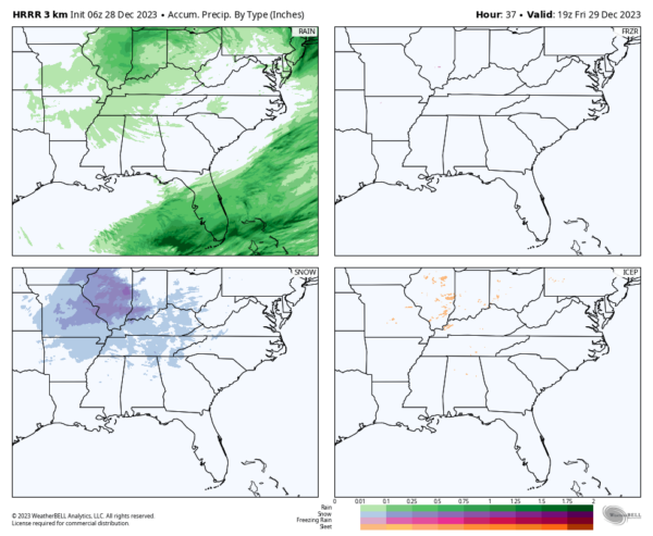
WINTRY PRECIP CHANCES? Clouds will begin increasing this afternoon ahead of that strong upper level disturbance swinging around the bottom of the upper level disturbance. A few light rain showers will begin showing up as early as late this afternoon over northwestern Alabama. Toward midnight, the showers could become mixed with some snow showers, first over the Tennessee Valley and Northeast Alabama, but gradually over much of North and Central Alabama north of I-20. The precipitation will continue much of the day across North and North Central Alabama. No significant impacts are expected, but some minor accumulations could show up over higher elevations of Northeast Alabama. Skies will remain mostly cloudy overnight as lows drop into the upper 20s and lower 30s.
NEW YEAR’S WEEKEND: Clouds will hang tough on Saturday with highs in the 40s and lower 50s. Clouds will be on the increase on Sunday, and rain will be returning well after midnight, so your New Year’s Eve celebrations will be dry. As you watch bowl games on Monday, the rain will be steady during the morning, and diminishing during the afternoon. Highs will be in the upper 40s and lower 50s.
VOODOO TERRITORY: As we sail into 2024, a Gulf low will develop and sail across the northern Gulf of Mexico. The rain associated with it will only affect extreme South Alabama. Another will follow on its heels, but with a track further to the north and more widespread rain across much of Alabama. A couple of systems will combine between the 10th and 12th to create more widespread rain and a wintry mix for parts of the South. How it will evolve, we will have to see.
GOING BOWLING: Auburn is in Nashville for the Music City Bowl vs Maryland. The snow shouldn’t be a problem by Saturday and game day. But it will be chilly, with highs in the 40s. Alabama fans will deal with a few showers on Saturday, but they should be out of the area by game time New Year’s Eve. Game day highs will be in the middle 60s.
BEACHCAST: It appears that rain will not return to the beautiful beaches of Alabama and Northwest Florida until New Year’s Day. Now that doesn’t mean great weather, but there will be plenty of sunshine. Highs will be in the 50s and 60s, and lows will be in the 30s and 40s. Water temperatures are in the lower 60s. The rip current risk has eased a bit and will be low to moderate into the weekend.
Click here to see the Beach Forecast Center page.
DANCING WITH THE STATS: Several daily rainfall records were set in the Northeast yesterday. Like 1.84″ at Wilmington, DE.
ADVERTISE WITH US: Deliver your message to a highly engaged audience by advertising on the AlabamaWX.com website. The site enjoyed over 29 MILLION page views in the past 12 months. Don’t miss out! We can customize a creative, flexible, and affordable package that will suit your organization’s needs. Contact me, Bill Murray, at (205) 687-0782 and let’s talk.
WEATHERBRAINS: This week, the panel visited with long time WGN weatherman and legend Tom Skilling. It is a remarkable interview. Check out the show at www.WeatherBrains.com. You can also subscribe on iTunes. You can watch the show live at live.bigbrainsmedia.com or on James’ YouTube Channel You will be able to see the show on the James Spann 24×7 weather channel on cable or directly over the air on the dot 2 feed.
ON THIS DATE IN 1996: Dense fog in the Tampa Bay area caused a series of chain reaction accidents on the soaring Sunshine Skyway Bridge, involving 50 vehicles. One person was killed and 24 injured. The 1280-foot span across the mouth of Tampa Bay was closed in both directions. Follow my weather history tweets on Twitter. I am @wxhistorian at Twitter.com.
Category: Alabama's Weather, ALL POSTS, Winter Weather


