Sunday Afternoon Update: A Nice, Soaking Rain Overnight into Christmas Morning
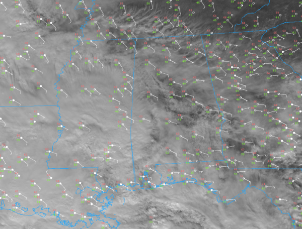
Multi-layered clouds are pretty thick across Alabama on this Christmas Eve early afternoon. There has been just enough sunshine for temperatures to warm into the lower and middle 60s across the entire area. Dewpoints are slowly rising but are still in the 40s and lower 50s.
Rain has reached southwestern portions of Alabama with light rain now being reported at Mobile, Fairhope, and Pensacola.
High pressure has a monopoly on the surface maps over the eastern United States, with centers over Nova Scotia, Ottawa, and Greenville, South Carolina.
Low-pressure centers are strung like pearls on a necklace from northern Minnesota to Kansas and Oklahoma as our next storm system takes a shot at unseating the king. The upper-level trough driving it all is over eastern New Mexico, where snow fell yesterday. Strong thunderstorms developed last evening over Southwest Texas and eastern New Mexico. Tree branches were blown onto a home near Ruidoso, NM, just one of four reports of wind damage reported.
Rain extends across much of Minnesota, eastern South Dakota, western Iowa, western Missouri, southeastern Kansas, eastern Oklahoma, much of Arkansas, eastern Texas, all of Louisiana,into southern Mississippi and Alabama.
The shortwave trough over the Land of Enchantment will take on an increasingly negative tilt today but weaken as it rotates northeast. The main upper system though will strengthen and close off into a strong upper low over western Kansas by Monday morning. A primary surface low will take over northwestern Missouri by tonight and will swing a long arm of rain showers slowly northeastward, pushing across Alabama overnight and into Christmas morning.
A few showers will be likely this evening across the area with the more solid area of rain pushing across the area after midnight. There could be a few rumbles of thunder overnight and early Christmas morning, but don’t worry about severe weather. You can just roll over and sleep peacefully, enjoying the rain.
There are hints that a disturbance could trigger some heavy rain over West Central and Central Alabama tomorrow morning. We can use the rain for sure. Rainfall totals according to the Weather Prediction Center could range between 1-1.5 inches with a couple of isolated spots receiving 2 inches.
Most of the rain will be east of I-65 by early afternoon, but there could be a stray shower at any point through sunset.
The upper low will be with us through the entire week ahead. The GFS hints that a few snow flurries or a little light snow could work it’s way into the Tennessee Valley by Thursday night as the upper low tracks across Tennessee just to our north. That will be fun to watch and see if it happens.
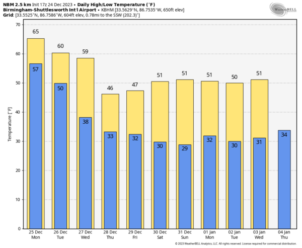
Temperatures off the National Blend of Models (for Birmingham, not Gulf Shores like I did this morning) look like this:
Have a great holiday. I will be manning the weather station in case anything changes.
Category: Alabama's Weather, ALL POSTS


