Your Weather Briefing for December 24, 2023: Rain for Christmas, then Cooler
Saturday featured beautiful weather for all three bowl games across Alabama, including some Chamber of Commerce Weather (or should I say Convention Bureau Weather) for the Birmingham Bowl at Protective Stadium.
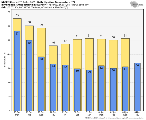
A PLEASANT START TO CHRISTMAS EVE: Hopefully, your Christmas planning is done and you and your families are ready to settle down for a little peace on Earth and good will to men. The weather will be cooperating today for any last minute preparations through the afternoon hours. Clouds will be thickening during the day, and a southeasterly breeze will be steady at about 10-15 mph. Those breezes may gust to 25 mph at time, especially tonight. The mercury will rise into the middle and upper 60s by afternoon.
SANTA’S FLIGHT WEATHER: The dewpoint is also rising slowly and will reach the 60F mark by early Monday as deeper moisture overspreads the area. As the surface low moves from southern Kansas to Central Oklahoma today, rain will begin pushing into Alabama from the southwest by midafternoon. Most of the day will be dry, but rain will be widespread during the evening and overnight. There could be a few rumbles of thunder mainly over the southern half of the area during the evening and overnight, but no strong storms are expected. Santa may encounter some MVFR and even IFR conditions, but he is fully instrument rated, and he has Rudolph. Overnight lows will be in the 50s.
CHRISTMAS DAY: We get off to a mild start, with temperatures in the 50s across the area. Rain showers will still be ongoing, and it will take until noon for them to be gone from areas west of I-65. Showers should be mainly gone by late afternoon, but a few could continue until after sunset in a few spots. Everyone should stay mostly cloudy through the day. The cold front will not arrive until after dark, so 60s will be common again on Monday. Winds will remain out of the southeast until the front passes in the evening hours. Those winds could be gusty at times. Lows Monday night will be in the 40s west and 50s east. Rainfall amounts will be generally in the one half to one inch range, with a couple of amounts over one inch over western sections.
REST OF THE WEEK: The big trough of low pressure bringing us the rain tonight through Monday will hang out most of the week over the eastern half of the country. This means cooler conditions, with lows gradually trending downward through the 30s into the 20s. Highs will be in the 50s Tuesday and Wednesday, but northern locations won’t get out of the 40s on Thursday. 40s will be common over North and Central Alabama on Friday.
LONG NEW YEAR’S WEEKEND: Saturday looks cool and dry, and so does New Year’s Eve. New Year’s Day looks dry too. So not a bad transition to 2024. But it will be chilly, with highs mainly in the 40s, and lows near freezing.
BOWL WEATHER: Weather looks dry and cool for the Music City Bowl in Nashville on Saturday with Auburn taking on Maryland. Game day highs will be in the 40s, as will the days leading up to the game. Lows will be in the upper 20s. Bama fans heading west will find warmer conditions for the Rose Bowl. Gameday highs will be in the middle 60s, with lows that morning in the middle 40s. Highs in the preceding week will be in the middle 60s as well, with lows also in the 40s.
VOODOO COUNTRY: Out through the week two forecast period, rain returns Thursday and Saturday, the 4th and the 6th. No wintry precip in the offing according to the models currently.
BEACHCAST: Rain for Christmas Eve and Christmas morning along the beautiful beaches of Alabama and Northwest Florida. The next rain chance after this weekend will come on New Year’s night. Near 70F today and tomorrow, with 60s Tuesday and Wednesday, and 50s through the weekend. Lows will be trending downward through the 50s and into the 40s and upper 30s in the week ahead. Surf will be increasing to between 4-6 feet today, with a high rip current risk and high surf advisory into late Monday and Tuesday. Water tempertures are in the lower 60s.
Click here to see the Beach Forecast Center page.
DANCING WITH THE STATS: A handful of record highs on Saturday across the Dakotas an d Minnesota, including Minot ND tying its record for the date with 47F and Bismarck SD tying theirs with 56F. Ashland MN tied theirs with 46F.
ADVERTISE WITH US: Deliver your message to a highly engaged audience by advertising on the AlabamaWX.com website. We have a lot of big plans for this year. Don’t miss out! We can customize a creative, flexible, and affordable package that will suit your organization’s needs. Contact me, Bill Murray, at (205) 687-0782 and let’s talk.
WEATHERBRAINS: Episode 935 recorded last Monday features our old friend Greg Carbin from the Weather Prediction Center. He gave us his 2023 Meteorological Memories. his annual top ten weather events. The show that we release tomorrow night features the incomparable Tom Skilling from WGN in Chicago. He will be retiring in early 2024 and we always look forward to talking to him. Check out the show at www.WeatherBrains.com. You can also subscribe on iTunes. You can watch the show live on our new YouTube channel for the show.You will be able to see the show on the James Spann 24×7 weather channel on cable or directly over the air on the dot 2 feed
ON THIS DATE IN 1963: The temperature at Memphis TN plummets to an unbelievable 13 degrees below zero, their all-time coldest reading. The extreme cold followed a very heavy 14.3 inch snowstorm. Follow my weather history tweets on Twitter. I am @wxhistorian at Twitter.com.
Category: Alabama's Weather, ALL POSTS


