Early Afternoon Forecast Update
Fortunately the death toll in the Tennessee/Kentucky tornadoes does not seem to have risen so far today. I saw where the NWS Louisville says that their part of the tornado that tracked out of Tennessee has been surveyed in Logan County, KY and they had found EF-2 damage Surrounding offices will have to finish their surveys before we will know the path length and overall intensity of this long tracked tornado.
The Weather Service in Paducah has checked in that the same tornado tracked across the entire width of Todd County and they found EF-2 damage. No news out of Nashville yet where their teams are underway on two surveys.
Here in Alabama, the biggest impact was hundreds of trees down across southern parts of the Birmingham Metro area including the suburbs of Homewood, Hoover, Vestavia, and Mountain Brook. Alabama Power crews have reduced outages in their areas to 10,393. Those numbers were around 35,000 right after the storms. We thank them and their amazing teams for the work they do to restore power after storms.
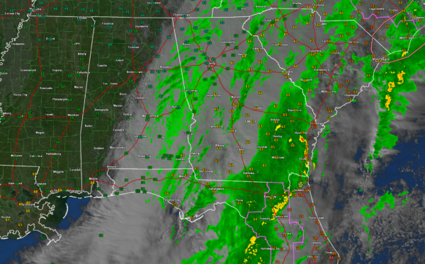
Skies are clearing from the west and northwest as expected behind a cold front. That front now lies from Lafayette to Tuskegee to Troy to Florala across Southeast Alabama. The clearing line extends from Fort Payne and Gadsden to Calera to Selma to Atmore.
Temperatures are in the 40s to lower 50s across the northern half of the state with lower 50s South, expect for the Wiregrass, where 60s are still hanging on for dear life.
Rain is limited to eastern counties from Cherokee down through Calhoun and Cleburne into Talladega/Clay/Randolph through the I-85 Corridor and on into Southeast Alabama.
The severe weather threat for Alabama is gone. The QLCS that moved through the state overnight extends all the way from southeastern Virginia through eastern North Carolina where tornado watches are in effect. It picks back up in southeastern Georgia into northern Florida, where another tornado watch is in effect for parts of the Peninsula. I just saw a 44 mph wind gust at Jacksonville International.
Lows tonight will be in the middle and upper 20 North with readings near 30F n South Central Alabama.
Tomorrow will be sunny and cool with highs struggling to get out of the 40s North, with lower to middle 50s South Central.
We stay dry through Friday it looks like, with rain returning to most of the state on Saturday afternoon and evening. Rain could stay with us much of Sunday as well. That’s good news as everyone can use the rain. 48 hour rainfall amounts for Saturday and Sunday look like they could average 1-2 inches. That would be just what the doctor ordered.
Out at the end of the period, the GFS is being much more bullish on rainfall for Christmas Eve and Christmas Day with another good soaker in store for Alabama. But no snow unfortunately, White Christmas fans! It did look like the rain would hold off until after the 76 Birmingham Bowl at Protective Stadium.
Category: Alabama's Weather, ALL POSTS, Severe Weather


