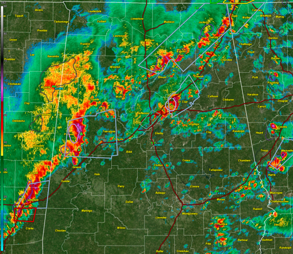
Radar Update at 10:45 p.m.
Our line of strong storms now extends from Jackson and DeKalb Counties in Northeast Alabama through Marshall, Cullman, Walker, Fayette, northern Tuscaloosa and Pickens Counties.
The strongest storm is over Pickens County in West Alabama near Carrollton. A significant weather advisory is in effect for parts of Pickens and Tuscaloosa Counties. 1 inch hail is possible along AL-86 between Carrollton and Gordo. This storm is lifting northeast and could stay north of the Tuscaloosa/Northport area, but it will be close. Expect very heavy rain, possible hail, and about 20-25 lightning flashes per minute. Winds coudl gust to 50 mph.
Heliciity values are still above 150 m2/s2, which means we can’t rule out a tornado and a tornado watch remains in effect.
Another decent storm is in eastern parts of Jefferson County moving into St. Clair County. The NWS in Birmingham just issued a flood advisory for eastern parts of Jefferson County.
The threat of severe weather will remain with us until the line of storms passes your location overnight. Have your weatheradio on alert if you go to bed. I will have frequent updates until the threat is cleared.
Category: Alabama's Weather, ALL POSTS, Severe Weather


