Latest Mesoscale Discussion — North Alabama Severe Risk Continues
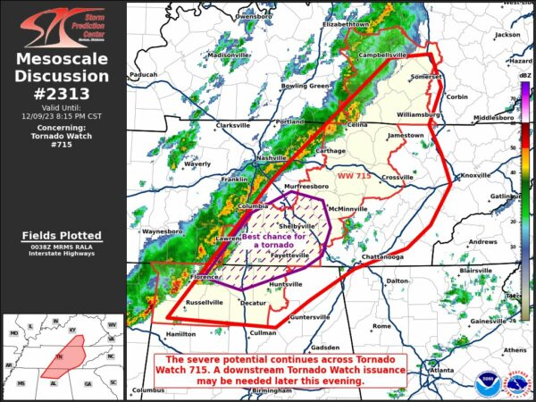
The threat for severe storms continue this evening for those locations under the current tornado watch, especially the locations close to the AL/TN state line. Damaging wind gusts now appear to be the main threat, but a brief tornado or two will be possible. An outflow boundary has moved out ahead of the front and main line of storms, which will actually help stabilize the atmosphere a little. Here is the latest from the SPC:
The severe weather threat for Tornado Watch 715 continues.
SUMMARY…The severe threat continues across Tornado Watch 715.
Damaging gusts appear to be the main threat, though a couple of
tornadoes remain possible, especially with storms closer to the
TN/AL border. The severe threat may persist eastward into northeast
AL and southeastern TN, where a WW issuance may ultimately be
warranted.
DISCUSSION…Thunderstorms have recently been merging into a loosely
organized squall line across middle TN into eastern MS and far
northwest AL, with MRMS mosaic radar data showing these storms
percolating in intensity. Low-level shear should remain strong
across the region as a 35+ kt low-level jet overspreads the TN
Valley (per 00Z mesoanalysis). Given linear storm modes, damaging
gusts should become the primary threat into the evening hours.
However, a few discrete cells remain near the AL/TN border, and
these storms have the best chance at producing a couple of tornadoes
into early tonight.
Despite waning buoyancy, the strong deep-layer and low-level shear
should compensate amid 500 J/kg MLCAPE to support some continuance
of severe potential into northeast AL and southeastern TN. Though
damaging gusts may be the main threat, given linear structures, the
elongated and curved hodographs suggest that some tornado potential
will also exist. A downstream Tornado Watch issuance may ultimately
be needed.
Category: Alabama's Weather, ALL POSTS, Severe Weather


