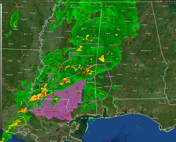
A 9:15 p.m. Look at the Alabama Weather Situation
We continue to track a dynamic storm system that is pushing into Alabama tonight. An upper level trough is approaching Alabama with a surface low along the Mississippi River near Vicksburg. A warm front extends east of the surface low from north of Jackson MS to north of Meridian on to near Selma and south of Montgomery to near Dothan. The values on the graphic are dewpoints.
There has been active severe weather in Louisiana and Mississippi this afternoon and evening. So far, no reports of major property damage or injuries.
Things are calming down in Mississippi now. Just one tornado warning left. One tornado warned storm is approaching I-59 southwest of Meridian and includes parts of Jasper County. It produce a TDS about an hour ago near Magee MS. Still 24 flashes of lightning per hour on that storm.
The Mississippi storms have very low instability (700-1,000 joules of CAPE) to work with, but extremely high shear (bulk shear values in the 71-76 m2s2 range and SRH 0-1km numbers in the 275-300 m2s2 range) to work with. The instability drops rapidly north of the warm front.
The rain and embedded thunder has now overspread the western third of Alabama. There just isn’t much lightning left north of I-20 in Mississippi so it should just be a rain event. There is just too much stable in place north of the warm front.
The SPC just put out a Mesoscale Discussion saying the storms could get into Southwest Alabama still overnight, generally for areas from southern Sumter through southwestern Marengo into Choctaw, Clarke, and Washington Counties including places like Butler, Grove hill and Chatom. Still could be a tornado watch for those areas.
There is a threat for severe weather on Tuesday across parts of South Alabama south and east of a line from Mobile to Selma to Wetumpka to Auburn and Opelika. Stronger activity could begin as early as 12 noon – 1pm in areas from around Montgomery, Alex City and Auburn back to the southwest to include places like Troy, Ozark Enterprise and Dothan through about 6-7 p.m. Areas from around Eufaula back to near Ozark should pay close attention in the later afternoon.
We will be watching the storms as long as they have any severe threat for severe weather and will be back at it tomorrow as well.
Category: Alabama's Weather, ALL POSTS, Severe Weather


