
Midday Nowcast: Strong Storms Arrive Late Tonight
RAIN AND STRONG STORMS ON THE WAY: Southerly winds are increasing today, allowing warm, moist air to surge north into Alabama. A Wind Advisory has been issued for the northern half of the state today, as non-thunderstorm winds could gust as high as 40 mph tonight. This afternoon, we are seeing a mix of sun and clouds, with temperatures climbing towards the 70s. A few showers are possible, but the main rain and storm threat arrives later tonight, and some strong and severe storms are expected.
A very dynamic storm system continues to organize to the west of Alabama and will push an organized batch of thunderstorms into and through the state late tonight and early tomorrow. It is a fairly typical November setup; very good dynamics, but weak thermodynamics. The SPC maintains a “slight risk” (level 2/5) for areas south and west of a line from Vernon to Marion to Monroeville to Gulf Shores through 7AM tomorrow morning.
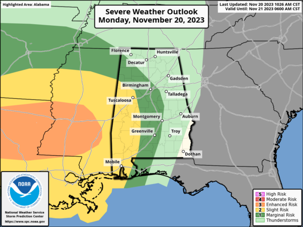
Much of the rest of the state, with the exception of the northeast counties, is in a “marginal risk” (level 1/5) for the remainder of the threat through tomorrow.
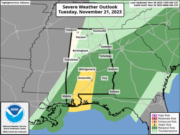
THREATS: The main threat will come from strong thunderstorm winds, but an isolated tornado or two can’t be ruled out. Highest risk of a tornado is in the “slight risk” area across parts of West and South Alabama. The window for strong to severe thunderstorms will begin across West Alabama around 10PM, with the threat spreading eastward during the late night and early morning hours. Storms should finally be clearing the southeast corner of the state by early tomorrow afternoon.
Beneficial rain is expected with this system across the state, with amounts of 1-2 inches expected statewide. Sure we need a a lot more, but it takes time to get rid of drought conditions, so this is hopefully a great start for the state.
CALL TO ACTION: Since most of the storms for the northern 2/3 of the state will come during the middle of the night, be sure you have a good way of hearing severe weather warnings in the event they are needed. The baseline is a NOAA Weather Radio, every home and business needs one! Be sure emergency alerts are enabled on your phone. Know the safe place in your home, and have helmets there for everyone in the family. If you live in a mobile home, know the location of the nearest shelter and how to get there quickly. Also be a hero, you can help us. Tell your friends, neighbors, and relatives about the threat, and what they need to do to get ready. You are our most valuable resource in spreading the word!
TOMORROW: We might see a few peeks of sun tomorrow, but the day will be generally cloudy with highs in the 60s. Storms will again be exiting the southeast corner of the state by the afternoon, and most of the day should be dry.
WEDNESDAY/THANKSGIVING: On Wednesday, a deep upper low will swing through the state. It will be a mostly cloudy and colder day with highs only in the upper 40s and lower 50s. A few sprinkles are possible under the upper low over the northern third of the state. Thanksgiving Day will be cool and dry with a partly sunny sky. We start the day in the upper 30s and low 40s, by the afternoon highs will be in the 50s for most of the state. Overall, a pretty decent Thanksgiving Day across Alabama.
FRIDAY AND THE WEEKEND: A low will move through the northern Gulf of Mexico, spreading some light rain northward into the state, but most of the rain will end early Friday and the greatest coverage of rain will be across southern sections of the state. By Friday afternoon and through the rest of the weekend, we are forecasting cool and dry weather with highs generally in the 50s, and lows in the 30s and 40s.
IRON BOWL FORECAST: We are expecting cool, dry weather for the biggest football game of the year Saturday (Alabama at Auburn; 2:30p CT kickoff). The sky will be partly sunny with a kickoff temperature near 60 degrees, falling into the 50s by the fourth quarter.
IN THE TROPICS: Two areas the NHC is monitoring, but have a low chance of development. Hurricane season officially ends at the end of the month.
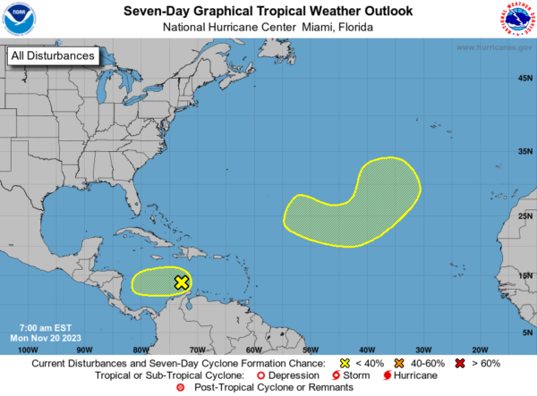
In the Central Caribbean Sea, shower and thunderstorm activity has increased somewhat in association with a small area of low pressure located over the central Caribbean Sea. However, environmental dry air is still likely to prevent significant development of this system as it begins to drift slowly westward later this week. Formation chance through 7 days…low…10 percent.
In the Central Subtropical Atlantic, a non-tropical area of low pressure is forecast to develop along a front over the central portion of the Atlantic basin during the next couple of days. Thereafter, environmental conditions appear somewhat conducive for this system to gradually acquire some subtropical or tropical characteristics during the latter part of this week while it moves generally eastward across the central subtropical Atlantic. Formation chance through 7 days…low…30 percent.
BEACH FORECAST CENTER: Get the latest weather and rip current forecasts for the beaches from Fort Morgan to Panama City on our Beach Forecast Center page. There, you can select the forecast of the region that you are interested in visiting.
WORLD TEMPERATURE EXTREMES: Over the last 24 hours, the highest observation outside the U.S. was 112.6F at Aracuai, Brazil. The lowest observation was -66.3F Dome A, Antarctica.
CONTIGUOUS TEMPERATURE EXTREMES: Over the last 24 hours, the highest observation was 90F at Rio Grande Village, TX. The lowest observation was 3F at Mount Washington, NH.
Category: Alabama's Weather, ALL POSTS
About the Author (Author Profile)
Macon, Georgia Television Chief Meteorologist, Birmingham native, and long time Contributor on AlabamaWX. Stormchaser. I did not choose Weather, it chose Me. College Football Fanatic. @Ryan_StinnetSubscribe
If you enjoyed this article, subscribe to receive more just like it.


