
Saturday Morning Weather Briefing Video: A Study in Perfection (Except Too Dry)
On this Saturday morning, as we approach the quiet tradition of ‘falling back,’ we’re participating in a historical ritual that spans back over a hundred years. The practice of Daylight Saving Time, begun during World War I to conserve energy, invites us to synchronize with the seasonal shift in a very tangible way. Tonight, when we set our clocks back one hour, we’re not just gaining extra sleep; we’re taking part in a shared legacy of adaptation—a collective pause and a nod to the past. As we prepare to reclaim that hour lost in the spring, let’s also look to the skies and anticipate what the weather has in store for us in the time we’ve borrowed back.
LOOK BACK AT FRIDAY: Yesterday’s weather was characterized by clear skies and temperatures that were slightly cooler than usual. The maximum temperature peaked at 68°F in the late afternoon, just below the average high of 69°F for this time of year, while the early morning minimum dipped to a chilly 35°F, a notable 12 degrees below the normal low. No precipitation was recorded, continuing the dry spell and contributing to a significant rainfall deficit for the month and the season.
A CHILLY START: Much of the area is starting off in the 30s this morning, with lower 40s limited to areas south of I-20. Sunny conditions will continue today with clear skies through the day and into the evening. A few clouds will appear tonight ahead of a dry cold front.
A WARMING TREND: Temperatures will be warming today, with daytime highs forecast to reach the lower to mid-70s.
FOOTBALL FORECAST: UAB hosts Florida Atlantic at Protective Stadium in downtown Birmingham (2:00p CT kickoff). The sky will be sunny with temperatures in the low 70s.
Auburn travels to Nashville to take on Vanderbilt (3:00p CT kickoff): the sky will be clear with upper 60s at kickoff, dropping into the low 60s by the final whistle.
And, Alabama will host LSU this evening at Bryant-Denny Stadium (6:45p CT kickoff): the sky will be clear with temperatures falling through the 60s. A perfect night for football in Tuscaloosa.
BUT CHILLY AGAIN TONIGHT: Overnight, temperatures will remain above freezing for most areas, with lows in the mid-30s to lower 40s, though colder valleys in the northeast may experience slightly lower temperatures.
SUNDAY: A dry mid- to upper-level trough will pass over the region, keeping the weather sunny and dry. Highs will stay comfortably in the 70s, thanks to the dry air mass and lingering low-level ridge.
THROUGH MIDWEEK: The warming trend will begin on Monday and persist through Wednesday, with dry conditions prevailing. Temperatures will gradually increase, with highs potentially reaching into the 80s by Hump Day. The ongoing lack of rainfall will continue to exacerbate drought conditions across the state.
DROUGHT CHECK: The drought situation across Alabama has gone downhill quickly. Extreme drought now covers nearly 29% of the state, across the Tennessee Valley and across Southwest Alabama. Nearly all of the rest of the state is in drought now, with less than 5% in just abnormally dry conditions and that is across the I-85 Corridor in East Central Alabama. Much of North Central Alabama is now in severe drought.
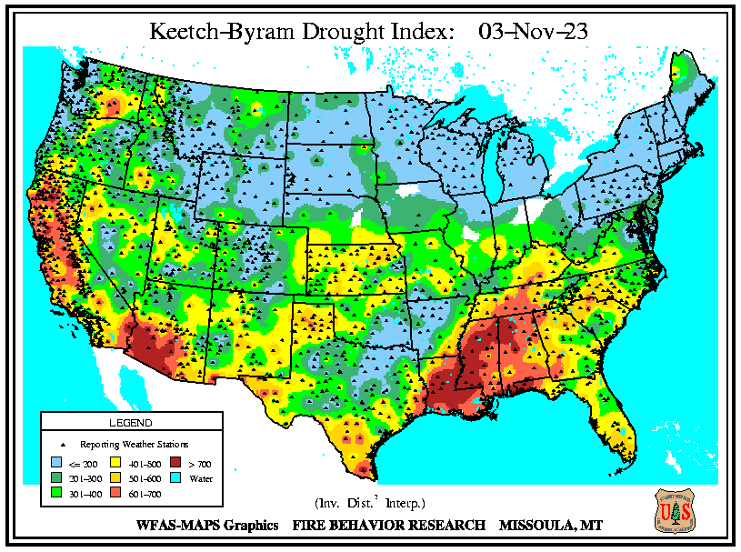
FIRE WEATHER THREAT: The National Weather Service Birmingham issues Red Flag Warnings based on a combination of factors that heighten fire risks. These typically include sustained winds or gusts of 15 mph or more, relative humidity levels at or below 25%, temperatures above 75 degrees Fahrenheit, and existing dry conditions or drought, specifically a Keetch-Byram Drought Index of over 500. The presence of dry vegetation also plays a crucial role in determining these warnings. We are clearly over 500 on the KBDI across all of Alabama. Humidities today will be in the 30-40% range and winds will not be a problem. But the combination of rising temperatures and a lack of significant rainfall into the next week indicates that drought conditions will worsen, maintaining ongoing concerns regarding the potential for fires, especially as winds pick up Wednesday and Thursday ahead of that next frontal system.
THURSDAY/FRIDAY: The later part of the week will see some change as a cold front is expected to move through the area, bringing a slight chance of rain late Thursday into early Friday. However, any precipitation will likely be light due to the weakening nature of the front. Temperatures will fall back, like our clocks, with highs in the 60s on Friday.
THE ELEMENT OF UNCERTAINTY: The GFS threw a monkey wrench into things with the 0z run last night, delaying the front until Saturday and giving it time to scoop up a little more moisture. More rain would be nice, but we can’t get our hopes up too much.
WEEKEND SNEAK PEEK: The weekend will feature dry conditions, with partly cloudy to partly sunny skies. Rain will return by Sunday evening, with perhaps our first decent rainfall in a while.
VOODOO TERRITORY: In the second week of the forecast period, fast moving systems to our north bring us glancing chances at precipitation, but nothing substantial. Temperatures hang near seasonal norms with highs in the upper 60s to near 70. Lows will be warming through the 50s.
BEACHCAST: Another spectacular week of weather long the beautiful beaches of Alabama and Northwest Florida with lots of sunshine, mild temperatures, still warm water, and low rip current risks. Highs all week will be in the 70s, with lows in the 50s. Water temperatures are still in the lower 70s. The next chance of rain along the coast won’t come until late next Sunday at the earliest.
Click here to see the Beach Forecast Center page.
IN THE TROPICS: We’re tracking Invest 97-L as it approaches Central America. This system, while still disorganized, is bringing substantial rainfall to the western Caribbean and is expected to make landfall later today. The main concern for Nicaragua, Honduras, Guatemala, and Belize is the heavy rainfall, which could lead to serious flash flooding and mudslides due to the intense downpours. Elsewhere, the Atlantic, Caribbean, and Gulf of Mexico remain calm, and with no further major tropical development expected soon, it appears we’re drawing close to the conclusion of the 2023 Hurricane Season.
NATIONALLY: Seattle and the Pacific Northwest are experiencing a storm system, with heavy downpours in the Olympics and Cascades, causing minor flooding. Winds could reach 40 to 50 mph, raising the risk of tree damage and power outages through today. Calmer weather is expected for Sunday.
DANCING WITH THE STATS: Lots of record low temperatures across the eastern Seaboard on Friday. How about 24F at Columbia SC? That beat the old record by 3 degrees. Martinsburg WV hit 21F tying their record for the date. Macon hit 26F, a record by 3 degrees.
ADVERTISE WITH US: Deliver your message to a highly engaged audience by advertising on the AlabamaWX.com website. The site enjoyed over 29 MILLION page views in the past 12 months. Don’t miss out! We can customize a creative, flexible, and affordable package that will suit your organization’s needs. Contact me, Bill Murray, at (205) 687-0782 and let’s talk.
WEATHERBRAINS: This week’s show is a November surprise, as our guest scheduled for tomorrow night has flaked out on us. Your faithful Guest Booking Officer, Bill, will be arranging for a substitute Guest WeatherBrain as soon as possible. Hopefully, before tomorrow night’s 7 p.m. air time. Check out the show at www.WeatherBrains.com. You can also subscribe on iTunes. You can watch the show live on our new YouTube channel for the show.You will be able to see the show on the James Spann 24×7 weather channel on cable or directly over the air on the dot 2 feed.
ON THIS DATE IN 1988: Fans of Parklaine Academy in McComb, MS, were crowded into their football stadium before a pivotal game when an F3 tornado touched down just 300 yards away. Fortunately, the tornado caused no injuries or fatalities. Follow my weather history tweets on Twitter. I am @wxhistorian at Twitter.com.
Category: Alabama's Weather, ALL POSTS
About the Author (Author Profile)
Bill Murray is the President of The Weather Factory. He is the site's official weather historian and a weekend forecaster. He also anchors the site's severe weather coverage. Bill Murray is the proud holder of National Weather Association Digital Seal #0001 @wxhistorianSubscribe
If you enjoyed this article, subscribe to receive more just like it.


