Midday Nowcast: Drought Conditions Increasing and Expanding across Alabama
TODAY THROUGH THE WEEKEND: After the freezing start this morning, a warming trend has started this afternoon, with highs closer to 60°. Tonight should feature another freeze for many locations. Tomorrow, highs will range from the 60s over North Alabama, to the low to mid 70s over the southern counties. The weekend will be dry with mostly sunny pleasant days and fair cool nights. Highs mostly in the 70s, lows in the 40s and 50s.
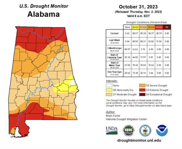
DROUGHT MONITOR: The latest drought monitor released this morning shows drought conditions are getting worse and expanding across the state. 95.38% of the state is dealing with the moderate drought up from 89.31% last week. Severe drought covers 58.37% of Alabama, while 28.70% of Alabama is now dealing with Extreme drought, up from 11.58% last week. We see no signs of beneficial rain the next 10-14 days for the state. Drought and fire weather dangers will continue to be an issue across Alabama.
FOOTBALL WEATHER: Expect a clear sky for the high school games across Alabama tomorrow night with temperatures falling through the 50s.
Saturday, UAB hosts Florida Atlantic at Protective Stadium in downtown Birmingham (2:00p CT kickoff). The sky will be sunny with temperatures in the low 70s.
Auburn travels to Nashville to take on Vanderbilt (3:00p CT kickoff)… the sky will be clear with upper 60s at kickoff, dropping into the low 60s by the final whistle.
And, Alabama will host LSU Saturday evening at Bryant-Denny Stadium (6:45p CT kickoff)… the sky will be clear with temperatures falling through the 60s. A perfect night for football in Tuscaloosa.
FALL BACK: Also this weekend, don’t forget time changes as Daylight Saving Time ends early Sunday morning, and we fall back onto Standard Time. Good news, we get an extra hour of sleep, bad news, sunset Sunday afternoon will be at 4:51PM for Birmingham. Always a great time to check the batteries in smoke and carbon monoxide detectors, and change those filters in your HVAC systems.
NEXT WEEK: We have removed the chance for showers early next week as the long dry spell continues. For the week, expect mainly sunny days with highs in the 70s. Nights will be clear and far with lows in the 40s and 50s.
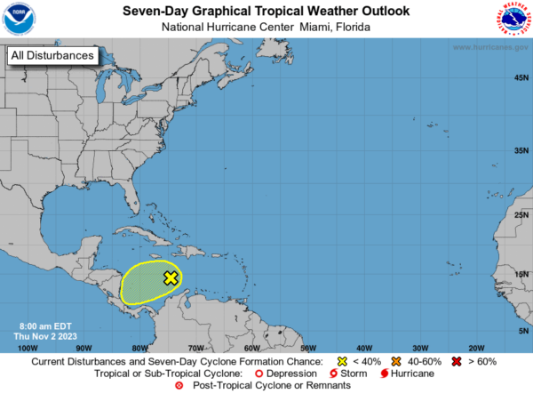
IN THE TROPICS: Just one feature we are watching currently in the Central Caribbean Sea. Disorganized showers and thunderstorms over portions of the central and western Caribbean Sea are associated with a broad area of low pressure. Development, if any, of this system is expected to be slow to occur before it moves inland over Central America on Saturday. Regardless of development, this system has the potential to produce heavy rains over portions of Jamaica through tonight and across Central America on Friday and over the weekend. Formation chance through 7 days…low…20 percent.
Hurricane season ends November 30th and the remaining names on list this year are Vince and Whitney.
BEACH FORECAST CENTER: Get the latest weather and rip current forecasts for the beaches from Fort Morgan to Panama City on our Beach Forecast Center page. There, you can select the forecast of the region that you are interested in visiting.
WORLD TEMPERATURE EXTREMES: Over the last 24 hours, the highest observation outside the U.S. was 112.6F at Marienta, Namibia. The lowest observation was -75.3F Dome A, Antarctica.
CONTIGUOUS TEMPERATURE EXTREMES: Over the last 24 hours, the highest observation was 92F at Santee and Yorba Linda, CA. The lowest observation was 2F at Davis, WV.
Category: Alabama's Weather, ALL POSTS


