Much Colder Air Arrives Early Next Week; Drought Conditions Intensify
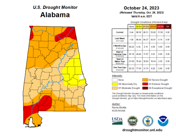
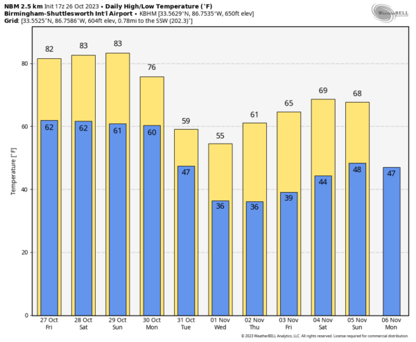
DRY: The new drought monitor was released this morning, and as expected drought conditions continue to intensify across Alabama. And, unfortunately we see no rain through the weekend. Look for partly to mostly sunny, warm afternoons and fair pleasant nights with highs in the low to mid 80s and lows in the 60s.
NEXT WEEK: A sharp cold front will pass through Alabama Monday, bringing some clouds, and possibly a few sprinkles. It will set up a huge thermal contrast; by afternoon some parts of the Tennessee Valley could be in the 40s, while the southern counties are in the 80s.
All of Alabama will be in the colder air Tuesday and Wednesday. Highs drop into the 50s over the northern half of the state both days, with 60s for the southern counties. Lows will be in the 30s over North/Central Alabama early Wednesday and Thursday morning, and some of the colder spots could see their first freeze of the season. For now we expect no rain over the latter half of the week… See the video briefing for maps, graphics, and more details.
FOOTBALL WEATHER: The sky will be clear for the high school games across Alabama tomorrow night with temperatures falling from the mid 70s at kickoff into the upper 60s by the quarter.
For Saturday’s Magic City Classic in Birmingham (Alabama State vs Alabama A&M, 2:30p CT kickoff at Legion Field)… the sky will be partly to mostly sunny with temperatures in the low to mid 80s. It will be a warm October afternoon.
Auburn hosts Mississippi State (2:30p CT kickoff) at Jordan Hare Stadium… dry and warm weather is the story with temperatures in the 81-84 degree for most of the game. The sky will be mostly sunny.
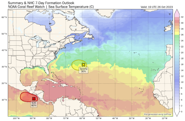
TROPICS: A strong extratropical cyclone (former Tammy) associated with an occluded front is located a few hundred miles east-southeast of Bermuda. There is a possibility that this system could regain tropical or subtropical characteristics while it meanders over the northwestern Atlantic through early next week. Regardless of development, the system has the potential to bring gusty winds and heavy rainfall to Bermuda during the next couple of days. Interests in the area should monitor the progress of this system.
The rest of the Atlantic basin is quiet.
ON THIS DATE IN 1952: There have been thousands of weather reconnaissance and research flights into hurricanes in the Atlantic and Pacific since the mid-1940s. There have been several close calls, but only four flights have been lost. A B-29 Super-fortress flight into Super Typhoon Wilma 350 miles east of Leyte in the Philippines disappeared on this date. No trace was ever found of the plane or crew. In the last report, the flight was in the Super typhoon’s strongest winds, which were around 160 mph.
ON THIS DATE IN 1998: Hurricane Mitch, the second deadliest hurricane in the Atlantic Ocean, reached Category 5 strength on this day.
Look for the next video briefing here by 6:00 a.m. tomorrow…
Category: Alabama's Weather, ALL POSTS, Weather Xtreme Videos


