Midday Nowcast: Drought Conditions Intensify across Alabama
DRY PATTERN PERSIST: Our weather will remain dry through the weekend, Halloween, and now looks like much of next week. Through the weekend, expect mainly sunny, warm days and fair nights. Temperatures will be in the upper 70s to mid 80s through through Sunday, while nights will range from the mid 50s to mid 60s.
FOOTBALL WEATHER: The sky will be clear for the high school games across Alabama tomorrow night with temperatures falling from the mid 70s at kickoff into the upper 60s by the quarter.
For Saturday’s Magic City Classic in Birmingham (Alabama State vs Alabama A&M, 2:30p CT kickoff at Legion Field)… the sky will be partly to mostly sunny with temperatures in the low to mid 80s. It will be a warm October afternoon.
Auburn hosts Mississippi State (2:30p CT kickoff) at Jordan Hare Stadium… dry and warm weather is the story with temperatures in the 81-84 degree for most of the game. The sky will be mostly sunny.
NEXT WEEK: A very sharp cold front will move through Alabama Monday. A few sprinkles are possible, but it won’t amount to a hill of beans. Behind the front, the coldest air so far this season will roll into the state late Monday and into Tuesday. Highs will drop into the 50s and 60s, while lows will hold fall into the 30s and 40s. Many locations across North Alabama, will likely see the first freeze of the season. Still no signs of meaningful or beneficial rain for Alabama the next 7-10 days.
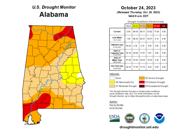
DROUGHT INTENSIFIES: The latest drought monitor released this morning continues to show the drought conditions continues to intensify across Alabama. Over half, 53.82% of the state, is suffering from at least severe drought conditions, with 11.58% in severe drought.
All of Alabama is screaming for rain, but it is not in the forecast anytime soon. With the lack of rain, drought conditions will continue to intensify. Due to low relative humidity values/dry air in place as well as the dry soil, fires will be able to start easily. Dispose of cigarettes properly, avoid leaving fires unattended, avoid dragging chains, and don’t do any outdoor burning.
IN THE TROPICS: Hurricane Tammy has become post-tropical but is still producing hurricane force winds. The post-tropical cyclone is moving toward the north near 12 mph. The system should begin to move northwestward later this morning, followed by a slower west-northwestward motion on Friday. Maximum sustained winds have decreased to near 85 mph with higher gusts. Some weakening is expected during the next few days. Hurricane-force winds extend outward up to 30 miles from the center and tropical-storm-force winds extend outward up to 195 miles. The estimated minimum central pressure is 973 mb (28.74 inches).
The rest of the basin is quiet. Hurricane season ends November 30th and the remaining names on list this year are Vince and Whitney.
BEACH FORECAST CENTER: Get the latest weather and rip current forecasts for the beaches from Fort Morgan to Panama City on our Beach Forecast Center page. There, you can select the forecast of the region that you are interested in visiting.
WORLD TEMPERATURE EXTREMES: Over the last 24 hours, the highest observation outside the U.S. was 111.7F at Augrabies Falls, South Africa. The lowest observation was -78.7F Dome A, Antarctica.
CONTIGUOUS TEMPERATURE EXTREMES: Over the last 24 hours, the highest observation was 94F at Weslaco, TX. The lowest observation was 3F at Neihart, MT.
Category: Alabama's Weather, ALL POSTS


