Cool, Dry Weather For Alabama Today
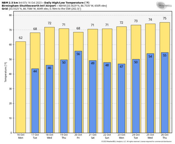
COOL, BREEZY WEATHER CONTINUES: With a partly sunny sky, we project a high in the low to mid 60s for much of Alabama today… some places across the Tennessee Valley won’t get out of the 50s. A northwest wind of 10-20 mph will make it feel cooler. We note the average high for Birmingham on October 16 is 76, so temperatures today are well below average. Tonight will be clear and very cool with a low in the 40s; some of the colder spots across North Alabama could reach the upper 30s.
REST OF THE WEEK: Look for sunshine in full supply tomorrow and Wednesday with a slow warming trend; highs will be in the low to mid 70s statewide by Wednesday afternoon. The day Thursday will be dry, but clouds will increase, and we will bring in a chance of rain statewide Thursday night and Friday ahead of a surface cold front. Moisture will be limited, and rain amounts will be light… generally under a quarter of an inch. The high Thursday will be in the low 70s, followed by a high in the 66-72 degree range Friday with a mostly cloudy sky.
THE ALABAMA WEEKEND: A nice surge of dry air rolls into the state Friday night, and the weekend will feature sunny pleasant days and clear cool nights. Highs between 68 and 73, with lows mostly in the 40s.
NEXT WEEK: A ridge will build across the Deep South, meaning dry weather is likely through the week with highs mostly in the 70s, along with lows in the 40s and 50s. See the video briefing for maps, graphics, and more details.
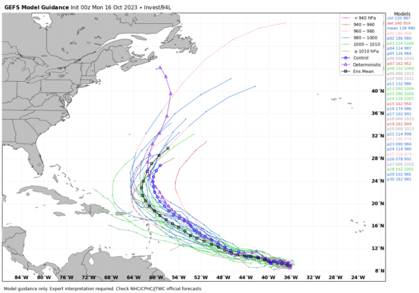
TROPICS: A broad area of low pressure (Invest 94L) located over the central tropical Atlantic is producing disorganized shower activity. Although the environment may not support much development during the next couple of days, conditions are expected to become more conducive thereafter, and a tropical depression is still likely to form by late this week. This system is expected to move westward or west-northwestward across the central and western tropical Atlantic during the next several days. NHC gives it a 70 percent of development over the next seven days.
Global models suggest that if this system develops, it will turn north before reaching the Lesser Antilles and will head out to sea; no threat to the U.S.
The rest of the Atlantic basin is quiet.
ON THIS DATE IN 1944: The 1944 Cuba – Florida hurricane, also known as the Pinar del Rio Hurricane, struck western Cuba on this day as a Category 4. This storm killed an estimated 300 people in Cuba and nine in Florida.
ON THIS DATE IN 1999: Hurricane Irene moved across the Florida Keys producing heavy rainfall, strong winds, and high waves. A gust 102 mph was reported in Big Pine Key.
Look for the next video briefing here by 3:00 this afternoon… enjoy the day!
Category: Alabama's Weather, ALL POSTS, Weather Xtreme Videos


