A Few Isolated Showers Tomorrow; Mostly Dry Weekend Ahead
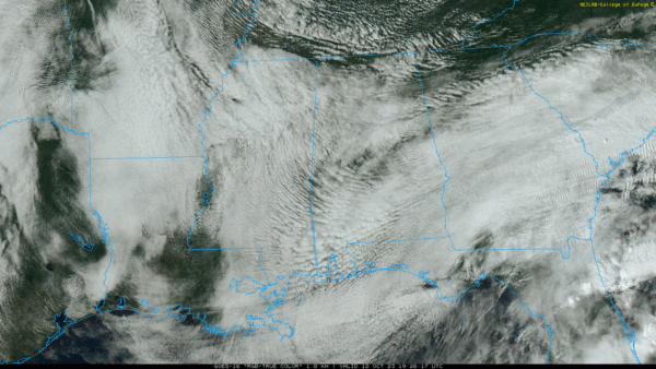
MOSTLY CLOUDY AFTERNOON: While the sun has broken out in a few spots, the sky is generally cloudy across Alabama this afternoon with temperatures mostly in the 67-74 degree range. Nothing on radar, and tonight will be dry with a low in the upper 50s and low 60s.
Tomorrow will be another mostly cloudy day across the state, and a disturbance could squeeze out out a few spotty showers, mainly over the northern and eastern counties. Nothing too widespread or heavy, and the high will be in the upper 60s and low 70s.
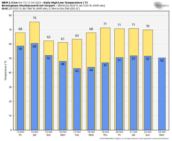
THE ALABAMA WEEKEND: On Saturday, early morning clouds will give way to a partly to mostly sunny sky with a high in the 70s. Sunday will be breezy and much cooler with a high only in the low to mid 60s. The sky will be occasionally cloudy, and a sprinkle or two can’t be ruled out as the cool air rushes into the state. A north wind of 10-20 mph will make it feel cooler. We drop into the 40s Monday morning.
NEXT WEEK: At this point the week looks cool and dry. Highs in the 60s through Wednesday, then in the low 70s Thursday and Friday. See the video briefing for maps, graphics, and more details.
FOOTBALL WEATHER: For the high school games tomorrow night, the sky will be mostly cloudy with just a small risk of a shower. Temperatures will fall from near 70 at kickoff to the mid 60s by the final whistle.
Saturday, Alabama hosts Arkansas at Bryant-Denny Stadium (11a CT kickoff). The sky will be partly to mostly sunny with temperatures rising from near 72 at kickoff, into the mid 70s by the fourth quarter.
Auburn will be in Baton Rouge to take on LSU (6:00p CT kickoff). The sky will be clear with temperatures falling from near 76 at kickoff, into the upper 60s by the final whistle.
UAB is also on the road… they will take on UTSA in San Antonio (7:00p CT kickoff). The Roadrunners play their home games at the Alamodome, so weather won’t be an issue. But for the fans headed that way Saturday will be a sunny day in San Antonio with a high in the mid 80s. It will be clear Saturday night with temperatures falling through the 70s after sunset.
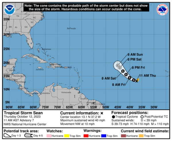
TROPICS: Sean is now a weak, sheared tropical storm in the Atlantic (winds of 40 mph) about 905 miles west/southwest of the Cabo Verde Islands. It will likely dissipate by Saturday far from land.
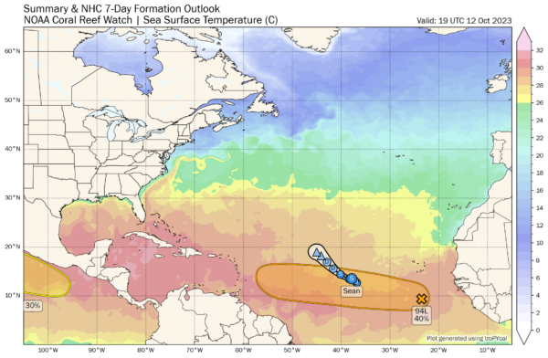
And, shower and thunderstorm activity is limited and disorganized this afternoon in association with a broad area of low pressure (Invest 94L) located
several hundred miles to the south of the Cabo Verde Islands. While environmental conditions are currently only marginally favorable for slow development over the next couple of days, they are forecast to become more favorable by early next week. A tropical depression could form by the middle of next week as this system moves generally westward across the eastern and central tropical Atlantic. NHC gives it a 40 percent chance of development.
SOLAR ECLIPSE SATURDAY: The annular solar eclipse (the path runs from parts of South Texas to Oregon) will be visible in Alabama as a partial eclipse. For Birmingham (and most of Alabama), it begins at 10:38a CT, peaks at 12:08p CT, and ends at 1:43p CT. At the peak 57.5 percent of the sun will be obscured by the moon. For now it looks like the sky will be mostly clear during the event here… be sure and use eclipse glasses from a reputable dealer! Never watch a solar eclipse with the naked eye or sunglasses.
ON THIS DATE IN 1962: The Columbus Day Storm of 1962 was a Pacific Northwest windstorm that struck the West Coast of Canada and the Pacific Northwest Coast of the United States. It is considered the benchmark of extratropical wind storms. The storm ranks among the most intense to strike the region since at least 1948, likely since the January 9, 1880 “Great Gale” and snowstorm.
ON THIS DATE IN 1979: The lowest barometric pressure ever recorded occurs in the center of Typhoon Tip. A fly reconnaissance mission recorded the low pressure of 870 mb or 25.69 inHg. Typhoon Tip was the most extensive tropical cyclone on record with a wind diameter of 1380 miles at its peak.
Look for the next video briefing here by 6:00 a.m. tomorrow…
Category: Alabama's Weather, ALL POSTS, Weather Xtreme Videos


