Cool, Dry Weekend Ahead For Alabama
**No video briefing this afternoon; I am live at Piedmont High School for Friday Night Rivals**
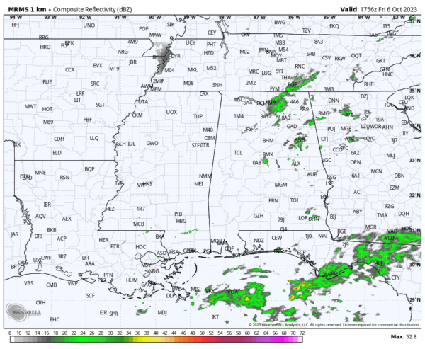
RADAR CHECK: Patches of light rain continue across Alabama this afternoon, mainly over the eastern half of the state, ahead of a sharp cold front. Light rain ends this evening, and the sky will clear late tonight as we experience a major airmass change.
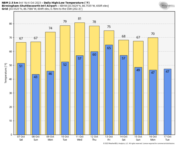
COOL WEEKEND: Tomorrow will be a sunny, breezy, very cool day with a high in the 60s over the northern half of the state. A brisk north wind of 10-20 mph will make it feel cooler. Temperatures reach the low to mid 70s across South Alabama. Sunday morning will feature a low in the 40s for most places, and some of the colder spots over the northern counties will see upper 30s for the first time since April. Sunday will be another sunny day with highs in the 60s and 70s.
NEXT WEEK: Dry weather continues for the first half of the week with a warming trend. Temperatures will be in the 40s early Monday for much of the state, but by Wednesday afternoon the high will be near 80. Global models continue to suggest potential for a good rain event on Thursday and Friday as moisture from the Gulf of Mexico surges northward… the latest data shows 1-2 inches for South Alabama, and 1/2 to 1 inch for the northern counties. Then, another surge of cool, dry air arrives for the following weekend (October 14-15). See the video briefing for maps, graphics, and more details.
FOOTBALL WEATHER: For the high school games tonight, a few widely scattered showers are possible across East and South Alabama. Otherwise expect a clearing sky with temperatures falling through the 60s with a fairly stiff north breeze.
Tomorrow, Alabama will be in College Station to take on Texas A&M (2:30p CT kickoff). About 72 degrees at kickoff with a mostly sunny sky. It will be a very pleasant afternoon.
UAB will host USF Saturday at Protective Stadium in downtown Birmingham (3:00p CT kickoff). The sky will be sunny with temperatures falling from near 67 at kickoff, into low 60s by the final whistle. The afternoon will be breezy with a north wind of 10-20 mph.
Troy will host Arkansas State (3p CT kickoff)… expect sunshine in full supply with a kickoff temperature near 72 degrees.
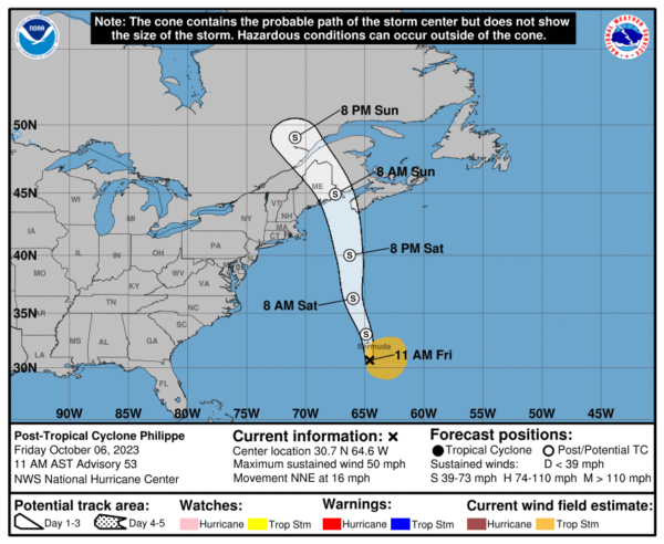
TROPICS: Has become post-tropical this afternoon near Bermuda; it will move into the coast of Maine/Nova Scotia early Sunday as a strong nor-easter.
Elsewhere, a low-latitude tropical wave is expected to move off the west coast of Africa in the next day or so. Thereafter, environmental conditions appear generally conducive for gradual development of the system. A tropical depression could form by the early to middle part of next week as the system moves westward to west-northwestward across the eastern tropical Atlantic. NHC gives the system a 50 percent chance of development. Models suggest this system will gain latitude and won’t be a threat to the Lesser Antilles or the U.S.
ON THIS DATE IN 2010: A significant severe weather event struck northern Arizona with at least eight confirmed tornadoes. This event will go down in history as the most tornadoes to hit Arizona in a single day. An EF2 tornado was on the ground for 34 miles, ranking as the longest-tracked tornado in Arizona history.
ON THIS DATE IN 2016: The center of Category 4 Hurricane Matthew passed within 100 miles of Miami. The storm then paralleled the coast of the southeastern United States over the next 36 hours, gradually weakening while remaining just offshore before making its fourth and final landfall over the Cape Romain National Wildlife Refuge near McClellanville, South Carolina as a Category 1 hurricane on the morning of October 8.
Look for my next video briefing here by 6:00 a.m. Monday… enjoy the weekend!
Category: Alabama's Weather, ALL POSTS, Weather Xtreme Videos


