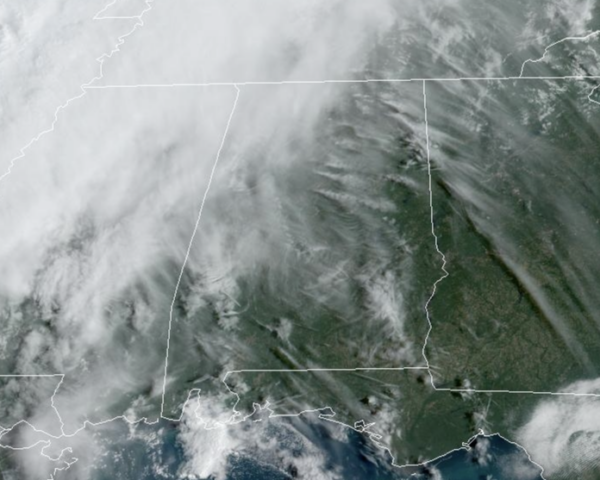
Midday Nowcast: Clouds Increasing as Front Approaches
More clouds in the Alabama sky today as the cold front continues to get closer. Highs today are ranging from the low to upper 80s. A few light rain showers will enter Northwest Alabama later this afternoon, but rain amounts will be light.
FRONT TOMORROW: A strong cold front will pass through the state tomorrow. Tomorrow will be mainly cloudy with some patchy light rain expected statewide, but again with limited moisture in place, beneficial rainfall just won’t happen as rainfall totals of less than a quarter of inch are expected. Certainly not the kind of rain we need, but some locations could see enough to settle the dust.
FANTASTIC FALL WEATHER: Behind the front, the coolest air so far this season will roll into Alabama for the weekend. Saturday will be quite breezy as a brisk, north wind will be blowing in the cooler air. Highs will drop into the upper 60s and low 70s, with lows in the 40s Sunday and Monday mornings. It will be downright chilly, and you will need those jackets out the door in the morning hours. We expect a good supply of sunshine both Saturday and Sunday.
FOOTBALL WEATHER: FOOTBALL WEATHER: For the high school games tomorrow night, a few widely scattered showers are possible. Otherwise mostly cloudy with temperatures falling through the 60s with a fairly stiff north breeze.
Saturday, Alabama will be in College Station to take on Texas A&M (2:30p CT kickoff). About 72 degrees at kickoff with a mostly sunny sky. It will be a very pleasant afternoon.
UAB will host USF Saturday at Protective Stadium in downtown Birmingham (3:00p CT kickoff). The sky will be sunny with temperatures falling from near 67 at kickoff, into low 60s by the final whistle. The afternoon will be breezy with a north wind of 10-20 mph.
NEXT WEEK: At this point next week looks generally rain-free with a slow warming trend. Highs early in the week will be in the 70s, but should reach the 80s by Thursday or Friday. Towards the end of the week, the long range models are showing a low moving along the Gulf Coast, and that could spread rain north into the state, but that is still a week away and forecast confidence remains low at this time.
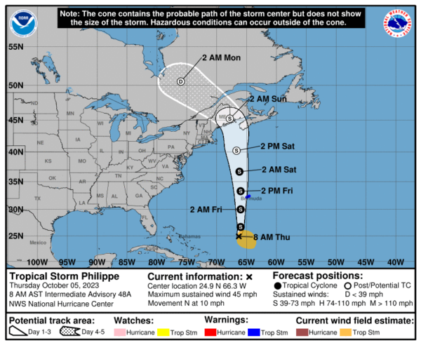
IN THE TROPICS: We only have one system in the Atlantic currently…Philippe. The center of Tropical Storm Philippe was located by an Air Force Reserve Hurricane Hunter aircraft near latitude 24.9 North, longitude 66.3 West. Philippe is moving toward the north near 10 mph. This general motion with an increase in forward speed is expected through Saturday. On the forecast track, the center of Philippe will pass near Bermuda on Friday, and approach eastern New England and Atlantic Canada on Saturday.
Maximum sustained winds are near 45 mph with higher gusts based on aircraft reconnaissance and Saildrone data. Additional gradual strengthening is forecast during the next few days. Philippe is forecast to become a post-tropical cyclone on Saturday as it approaches Atlantic Canada and New England. Tropical-storm-force winds extend outward up to 230 miles to the east of the center. Saildrone SD-1041, located about 100 miles east-southeast of Philippe’s center, recently measured a sustained wind of 40 mph and a gust to 47 mph. The minimum central pressure based on dropsonde data is 1005 mb.
The rest of the basin is quiet with no tropical development expected the next seven days. The remaining names on list this year are Sean, Tammy, Vince, and Whitney.
BEACH FORECAST CENTER: Get the latest weather and rip current forecasts for the beaches from Fort Morgan to Panama City on our Beach Forecast Center page. There, you can select the forecast of the region that you are interested in visiting.
WORLD TEMPERATURE EXTREMES: Over the last 24 hours, the highest observation outside the U.S. was 124.3F at Siteki, Eswatini. The lowest observation was -93.3F Concordia, Antarctica.
CONTIGUOUS TEMPERATURE EXTREMES: Over the last 24 hours, the highest observation was 103F at Rio Grande Village, TX. The lowest observation was 21F at Angel Fire, NM.
Category: Alabama's Weather, ALL POSTS


