Dry Through Much Of Next Week
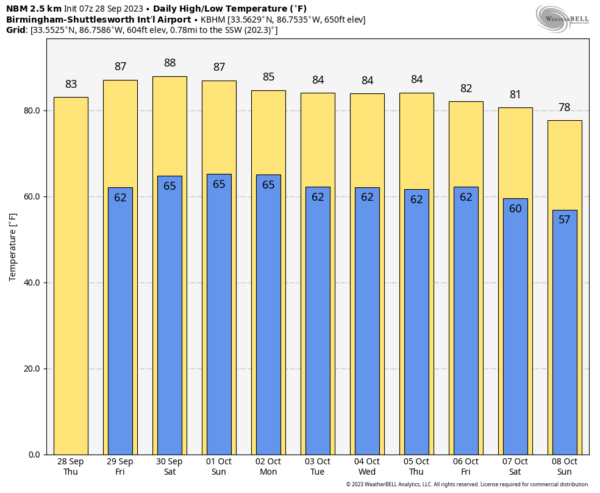
DRY IS THE WORD: Today will be the 12th consecutive day with no measurable rain at Birmingham, and there is no sign of any rain for the next seven days. Today will feature a sunny sky with a high in the 80s. Sunny warm days, fair pleasant nights will continue through the weekend with highs in the 86-91 degree range tomorrow through Sunday.
NEXT WEEK: Not much change. Dry weather continues through at least Thursday with highs in the 80s. We are starting to see some evidence in global models that a cold front will approach Friday with some risk of showers, but it most likely won’t be a big rain event. Cooler air will likely arrive after the front by the following weekend (October 7-8)… See the video briefing for maps, graphics, and more details.
FOOTBALL WEATHER: The sky will be mostly fair for the high school football games across Alabama tomorrow night with temperatures falling through the 70s.
Saturday, UAB travels to New Orleans to take on Tulane (11:00a CT kickoff). The sky will be partly too mostly sunny with an outside risk of a brief shower or storm during the game. Temperatures will rise from near 84 at kickoff to 88 degrees by the final whistle.
Auburn hosts Georgia at Jordan-Hare Stadium (2:30p CT kickoff)… the sky will be mostly sunny. Temperatures will hover in the mid to upper 80s through most of the game.
And, Alabama will be in Starkville to take on Mississippi State (8:00p CT kickoff). Expect a clear sky with temperatures falling through the 70s.
RACE WEEKEND: Sunny warm days, fair nights at Talladega today through the weekend with highs in the 80s.
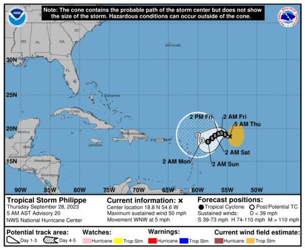
TROPICS: Tropical Storm Philippe is hanging in there this morning with winds of 50 mph, about 550 miles east of the northern Leeward Islands. The system is drifting to the west at only 5 mph, and is still expected to become a remnant low in a few days due to dry air and shear.
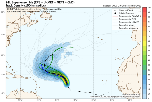
A tropical wave (Invest 91L) is training Philippe in the Atlantic, and is expected to become Tropical Storm Rina soon, but it will turn to the north and is no threat to land.
No tropical systems are expected near the Gulf of Mexico for at least the next seven days.
ON THIS DATE IN 1998: Hurricane George made landfall near Biloxi with maximum winds of 110 mph and a minimum pressure of 964 mb, making it a Category 2 hurricane. After landfall, Georges moved very slowly across southern Mississippi and weakened to a tropical depression by the morning of the 29th when the center was about 30 miles north-northeast of Mobile. Hurricane Georges produced a storm surge of 7-12 ft in Mobile and Baldwin Counties with a 5-10 ft surge across the western Florida Panhandle, which caused extensive damage across coastal communities.
ON THIS DATE IN 2022: Ian peaked as a Category 5 hurricane with sustained winds of 160 mph early on September 28, while progressing towards the west coast of Florida, and made landfall just below peak intensity in Southwest Florida on Cayo Costa Island. In doing so, Ian tied with several other storms to become the 5th-strongest hurricane on record to make landfall in the contiguous U.S.
Hurricane Ian caused 161 fatalities: 5 in Cuba, 150 in Florida, 5 in North Carolina, and 1 in Virginia. Ian caused catastrophic damage with losses estimated to be around $113 billion, making it the costliest hurricane in Florida’s history, surpassing Irma of 2017, as well as the third-costliest in US history, behind only Katrina of 2005 and Harvey of 2017 respectively. Much of the damage was from flooding brought about by a storm surge of 10–15 ft.
The cities of Fort Myers, Cape Coral, and Naples were particularly hard hit, leaving millions without power in the storm’s wake and numerous inhabitants forced to take refuge on their roofs. Sanibel Island, Fort Myers Beach, and Pine Island bore the brunt of Ian’s powerful winds and its accompanying storm surge at landfall, which leveled nearly all standing structures and collapsed the Sanibel Causeway and the Matlacha Bridge to Pine Island, entrapping those left on the islands for several days.
Look for the next video briefing here by 3:00 this afternoon… enjoy the day!
Category: Alabama's Weather, ALL POSTS, Weather Xtreme Videos


