Midday Nowcast: Some Sun, Some Clouds, and Very Warm Temperatures
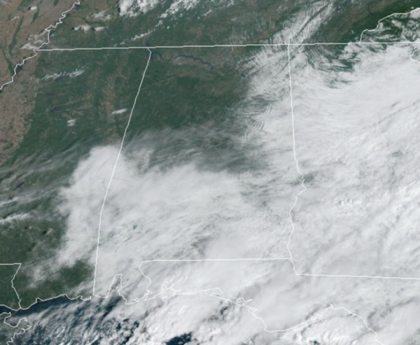
REST OF TODAY: Most of North/Central Alabama is seeing sunshine today, while clouds and showers are more common across the southern sections of the state. For the northern half of the state, rain chances are low and it is a very warm day with afternoon highs in the mid to upper 80s, with still a few low 90s possible. Tonight, the sky will be clear as lows fall into the low and mid 60s.
TOMORROW THROUGH WEEKEND: Drier weather highlights the forecast starting tomorrow and will continue right on through the weekend as an upper-ridge builds in over the region. Highs will be in the low to mid 80s most days, while some spots could see upper 80s. Lows will generally be in the 60s. Humidity levels will be low, so it will be comfortable with sunny days and fair, pleasant nights.
FOOTBALL WEATHER: The sky will be mostly fair for the high school football games across Alabama Friday night with temperatures falling through the 70s.
Saturday, UAB travels to New Orleans to take on Tulane (11:00a CT kickoff). The sky will be partly too mostly sunny with an outside risk of a brief shower or storm during the game. Temperatures will rise from near 84 at kickoff to 88 degrees by the final whistle.
Auburn hosts Georgia at Jordan-Hare Stadium (2:30p CT kickoff)… the sky will be mostly sunny. Temperatures will hover in the mid to upper 80s through most of the game.
And, Alabama will be in Starkville to take on Mississippi State (8:00p CT kickoff). Expect a clear sky with temperatures falling through the 70s.
FIRST WEEK OF OCTOBER: Much of next week looks fairly routine for early fall and October in Alabama. Quiet, dry, and warm as the ridge will likely keep much of Alabama and the Deep South dry through the week with highs in the 80s. The prospect of a big rain event is looking low for at least the next 7-10 days. Remember is should be dry this time of year, October is statistically our driest month of the year in Alabama.
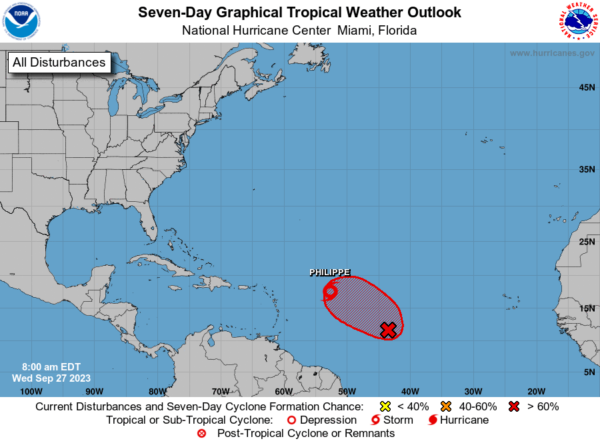
TROPICAL STORM PHILIPPE: Philippe is moving toward the west near 12 mph, and a westward to west-northwestward motion is expected over the next few days. Maximum sustained winds are near 45 mph with higher gusts. Gradual weakening is forecast during the next few days and Philippe is expected to dissipate near the Great Antilles by this weekend. Tropical-storm-force winds extend outward up to 205 miles from the center. The estimated minimum central pressure is 1003 mb (29.62 inches).
ELSEWHERE IN THE TROPICS: We are likely to soon have Rina in the Central Tropical Atlantic. Showers and thunderstorms continue to show signs of organization in association with an area of low pressure located roughly halfway between the Cabo Verde Islands and the Lesser Antilles. Environmental conditions are forecast to be conducive for development, and a tropical depression or storm is expected to form in the next day or so while the system moves west-northwestward across the central tropical Atlantic. Formation chance through 48 hours…high…90 percent.
Remaining names on list this year are Rina, Sean, Tammy, Vince, and Whitney.
BEACH FORECAST CENTER: Get the latest weather and rip current forecasts for the beaches from Fort Morgan to Panama City on our Beach Forecast Center page. There, you can select the forecast of the region that you are interested in visiting.
WORLD TEMPERATURE EXTREMES: Over the last 24 hours, the highest observation outside the U.S. was 115.0F at Kuwait International Airport, Kuwait. The lowest observation was -82.7F Vostok, Antarctica.
CONTIGUOUS TEMPERATURE EXTREMES: Over the last 24 hours, the highest observation was 105F at Phoenix, AZ. The lowest observation was 20F at Angel Fire, NM.
Category: Alabama's Weather, ALL POSTS


