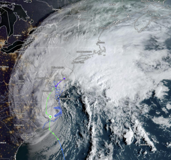
Ophelia Makes Landfall in North Carolina as a Very Strong Tropical Storm
As of 5:15 am this morning, the center of Tropical Storm Ophelia moved onshore near Emerald Isle in North Carolina with maximum sustained winds around 70 mph… just shy of category one hurricane strength.
The latest Satellite image as of 7 am shows the storm, which looks like the head of the alien from “Alien,” shows that dry air is being pulled into the right side of the storm. The latest update has the maximum sustained winds down to 65 mph and currently moving northward at 13 mph. Here are the key messages from the NHC:
- Tropical storm conditions are expected along portions of the southeastern and mid-Atlantic U.S. coasts within the Tropical Storm Warning area through tonight. Hurricane conditions are possible within the Hurricane Watch area early this morning.
- There is a danger of life-threatening storm surge inundation over portions of eastern North Carolina and southeastern Virginia, including Pamlico and Albemarle Sounds, the Neuse and Pamlico Rivers, the lower James River, and the lower Chesapeake Bay, where Storm Surge Warnings are in place.
- Heavy rainfall from this system may produce locally considerable flash, and urban flooding impacts across portions of the Mid-Atlantic states from North Carolina to New Jersey through Sunday.
- Swells generated by this system will affect much of the U.S. east coast through the weekend, likely causing life-threatening surf and rip currents.
Ophelia is forecast to become extratropical within the next 24–36 hours, and the extratropical low will dissipate over the Delmarva Peninsula when it becomes absorbed within a frontal zone.
Category: ALL POSTS, Severe Weather, Tropical


