Midday Nowcast: Some Showers and Storms Today
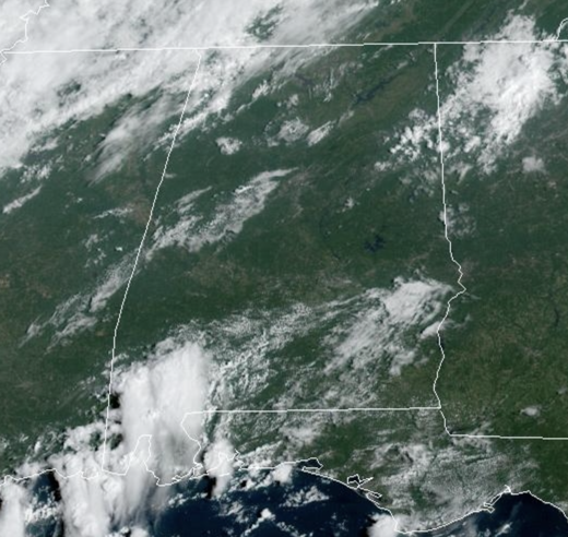
Showers and storms will be more numerous this afternoon and evening ahead of an approaching front. Any storm this afternoon will produce loads of lightning, gusty winds, and very heavy rainfall…though a few strong storms are possible, organized severe storms are in not in the forecast today. Highs today are in the upper 80s to lower 90s.
REST OF WEEK: As the front sags south, drier air slips into the northern half of the state tomorrow and Thursday. Highs these two days will drop into the low and mid 80s. On Friday, the chance of showers will increase statewide as a surface trough develops over the region. It won’t rain all day, but a few showers and possibly a thunderstorm are a good bet through Friday night.
FRIDAY NIGHT LIGHTS: For the high school games Friday night, periods of rain are possible with a mostly cloudy sky…some thunder can’t be ruled out. Temperatures will fall through the 70s.
WEEKEND WEATHER: We will maintain the risk of a some showers and storms over the weekend, but it certainly won’t be a “wash-out,” and the sun will be out at times. Rain chances this weekend will be in the 40-60% range. Highs will remain in the low 80s for North Alabama, with mid to upper 80s to the south. As the trough moves east late Sunday, drier air is expected to settle into the state next week.
FOOTBALL WEATHER: Saturday, Alabama travels to Tampa to take on South Florida (2:30p CT kickoff)… the day will be hot and humid with a kickoff temperature around 90 degrees. A passing shower or thunderstorm is possible during the game.
Auburn hosts Samford Saturday evening at Jordan-Hare Stadium (6:00p CT kickoff)… the sky will be mostly cloudy with some rain possible at times. Temperatures will be in the mid to upper 70s.
And, UAB will host Louisiana Saturday evening in downtown Birmingham at Protective Stadium (6:00p CT kickoff)… much like Auburn, a few periods of rain are possible during the game. Mostly cloudy conditions with temperatures falling from near 80 at kickoff, to mid 70s by the fourth quarter.
NEXT WEEK: For now a very dry airmass for the Deep South, and most of the week looks rain-free with highs in the 80s and lows in the 60s, right at seasonal averages. We are slowly seeing the transition from summer to fall across the Deep South, just be patient.
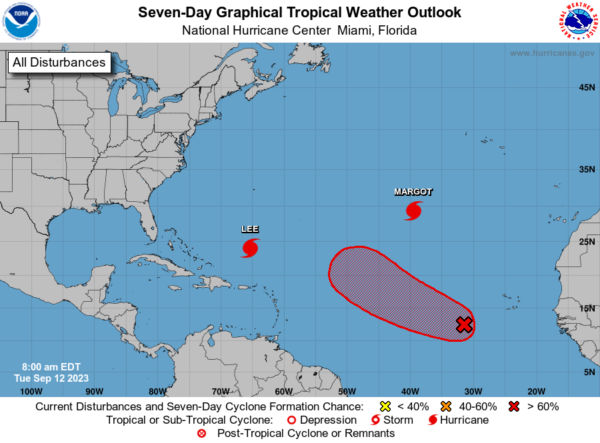
IN THE TROPICS: We have Hurricane Lee, Hurricane Margot, and at some point of the next week, Nigel. This broad area of low pressure over the eastern tropical Atlantic continues to produce disorganized showers and thunderstorms. This system is expected to consolidate, with a low on the western side becoming dominant over the next day or two. Gradual development of the low is expected after that and a tropical depression is likely to form by this weekend while the system moves west-northwestward or northwestward at about 15 mph across the central tropical Atlantic. Formation chance through 7 days…high…70 percent.
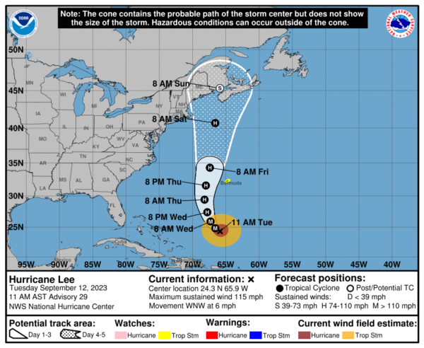
HURRICANE LEE: Lee is moving toward the west-northwest near 6 mph. A slow west-northwest to northwest motion is expected during the next day or two, followed by a turn toward the north by midweek. On the forecast track, Lee is expected to pass near but to the west of Bermuda in a few days. NOAA Hurricane Hunter data indicate that the maximum sustained winds remain near 115 mph with higher gusts. Lee is a category 3 hurricane on the Saffir-Simpson Hurricane Wind Scale. Some slow weakening is forecast during the next 48 hours, but Lee is expected to remain a large and powerful hurricane. Hurricane-force winds extend outward up to 90 miles from the center and tropical-storm-force winds extend outward up to 205 miles. The estimated minimum central pressure is 951 mb (28.09 inches) based on dropsonde data.
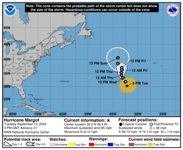
HURRICANE MARGOT: Margot is moving toward the north near 12 mph. A turn toward the north-northwest at a slower forward speed is expected beginning tomorrow, followed by a turn back generally toward the north at an even slower speed on Thursday and Friday. Maximum sustained winds are near 85 mph with higher gusts. Little change in strength is expected for the next several days, but short term fluctuations, up or down, are possible. Hurricane-force winds extend outward up to 35 miles from the center and tropical-storm-force winds extend outward up to 255 miles. The estimated minimum central pressure is 975 mb (28.80 inches).
BEACH FORECAST CENTER: Get the latest weather and rip current forecasts for the beaches from Fort Morgan to Panama City on our Beach Forecast Center page. There, you can select the forecast of the region that you are interested in visiting.
WORLD TEMPERATURE EXTREMES: Over the last 24 hours, the highest observation outside the U.S. was 118.2F at Omidieh, Iran. The lowest observation was -95.8F Vostok, Antarctica.
CONTIGUOUS TEMPERATURE EXTREMES: Over the last 24 hours, the highest observation was 111F at Rio Grande Village, TX. The lowest observation was 23F at Foxpark, WY.
Category: Alabama's Weather, ALL POSTS


