Generally Dry Weather Continues Through Early Next Week
**No afternoon video today; I am at Pell City High School for the Friday Night Rivals game of the week**
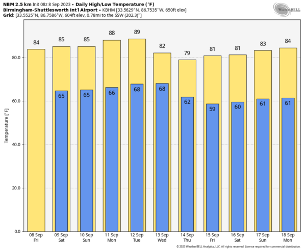
SUNNY FRIDAY: It is a fine early September day across Alabama. With ample sunshine, temperatures are in the 80s over North Alabama… some South Alabama communities have reached the low 90s. Tonight will be fair with a low in the 60s… cooler spots will visit the 50s.
Not much change over the weekend… mostly sunny warm days and fair pleasant nights. We will mention some risk of isolated showers near the Georgia state line, but even there the chance of any one spot seeing rain is only 10-15 percent. Highs will hold in the 80s over North Alabama, with low 90s to the south.
NEXT WEEK: Dry weather is expected Monday and Tuesday… then we will introduce some risk of showers on Wednesday and Thursday ahead of a cold front. Rain amounts are expected to be light and spotty with only limited moisture available. Then, a surge of drier and cooler air arrives by the end of the week with highs dropping into the upper 70s over the northern counties of Alabama. See the video briefing for maps, graphics, and more details.
FOOTBALL WEATHER: The sky will be clear for the high school football games across Alabama tonight with temperatures falling through the 70s.
Tomorrow, UAB will take on Georgia Southern in Statesboro, GA (5:00p CT kickoff)… the sky will be occasionally cloudy, and a passing shower or thunderstorm is likely during the game. Temperatures will fall from near 86 degrees at kickoff through the 80s during the second half.
Alabama will host Texas tomorrow evening at Bryant-Denny Stadium (6:00p CT kickoff)… the sky will be clear with temperatures falling from near 83 degrees at kickoff, into the 70s by the second half.
Auburn will be in Berkeley to take on the California Golden Bears (9:30p CT kickoff)… expect a clear sky with temperatures in the 60s during the game.
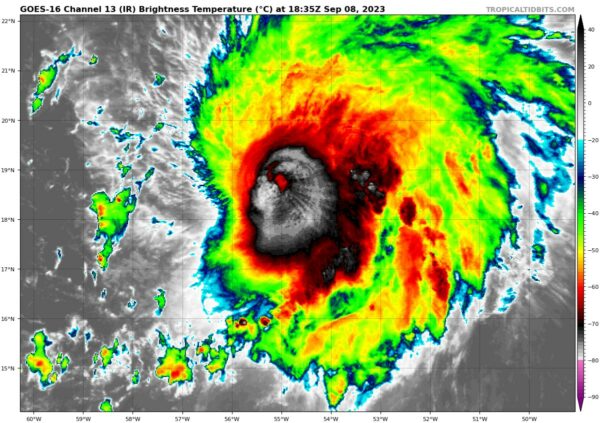
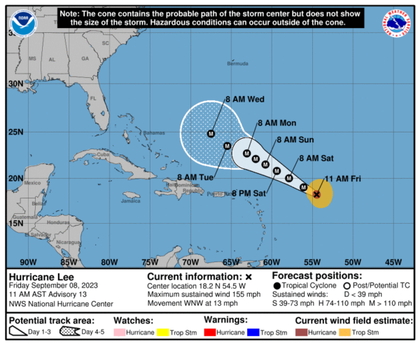
TROPICS: Category four Hurricane Lee is about 550 miles east of the northern Leeward Islands this afternoon, and is packing sustained winds of 155 mph. There will be fluctuations in intensity due to eyewall replacement cycles (ERC), but the hurricane is expected to remain at category 4/5 strength for the next five days.
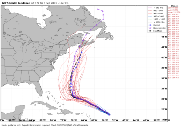
The official NHC track takes Lee to a point east of the Bahamas by Wednesday. From there, ensemble output from global models continue to show a sharp turn to the north, keeping Lee east of the East Coast of the U.S. There is unusually good agreement with the members of the ensemble, leading to a high confidence forecast in the concept of the turn.
Lee could be close to either the coast of Maine or Nova Scotia in 7 days, however, and everyone there needs to pay close attention to the hurricane in coming days.
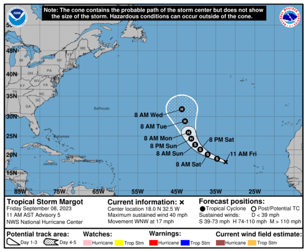
The other system on the board is Tropical Storm Margo in the eastern Atlantic; this is expected to become a hurricane by Sunday night, but it will turn north and is no threat to land.
No tropical systems will threaten the Gulf of Mexico for at least the next seven to ten days.
ON THIS DATE IN 1900: A Category 4 storm made landfall in Galveston, Texas. This hurricane killed between 8,000 and 12,000 individuals, making it the deadliest US Atlantic hurricane on record. The highest point in the city of Galveston was less than nine feet above sea level. The hurricane brought a storm surge of over 15 feet, which overwhelmed the entire island.
ON THIS DATE IN 2012: Severe storms impacted the New York City area, forcing a delay of the United States Open. A tornado hit a beach club in Queens, and another brought damage to Canarsie, Brooklyn, New York.
Look for my next video briefing here by 6:00 a.m. Monday… enjoy the weekend!
Category: Alabama's Weather, ALL POSTS, Weather Xtreme Videos


