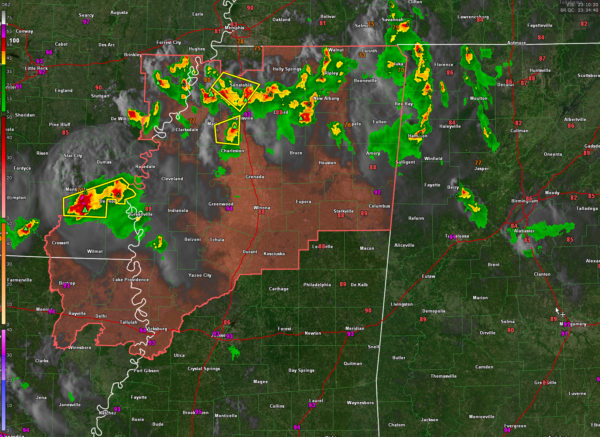
Severe Thunderstorm Watch for Much of Northern Mississippi, Strong Storms Over Alabama
The SPC in conjunction with local NWS offices has issued a severe thunderstorm watch for much of the northern half of Mississippi extreme eastern Arkansas and northeastern Louisiana until 11 p.m. CDT.
The watch does not include any Alabama counties at this time, although that is a possibility later.
There are several severe thunderstorm warnings across the watch area at this time.
Strong storms are into Northwest Alabama, but they are not severe. The strongest storms are in a line from Savannah TN to just west of Russellville in Franklin County, Alabama to near Hamilton in Marion County. This is a line of storms that will be pushing east southeast over the next few hours. They will have to be watched for severe potential. Decent CAPE, decent Lapse Rates, barely enough shear to stay organized and no tornado threat. Lightning is pretty intense, especialy in that Marion County storm.
Other storms are over southeastern Fayette County and northern Tuscaloosa County.
A weakening storm passed through the Birmingham Metro area a short while ago.
There is a risk of severe weather tonight northwest of a line from Reform to Eva to Skyline. The greatest threat is over parts of Lamar, NW Tuscaloosa, Marion, Franklin, Colbert, and Lauderdale Counties. Damaging winds and hail are possible. There is no significant tornado threat.
Category: ALL POSTS, Severe Weather


