Strong Storms Possible Late This Afternoon And Tonight
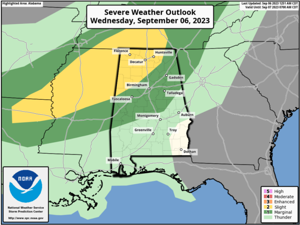
ACTIVE STORMS LATER TODAY: We have a few showers over Northeast Alabama early this morning, but the weather is dry elsewhere with temperatures in the 68-73 degree range at daybreak. A disturbance will bring potential for active thunderstorms in here later today; SPC has defined a “slight risk” (level 2/5) of severe thunderstorms for areas north of a line from Reform to Hanceville to Scottsboro. A “marginal risk” (level 1/5) extends down to Linden, Prattville, and Ranburne.
The window for the heavier storms will come from around 4:00 until 10:00 p.m… and the main concern is from strong straight line winds. It won’t rain everywhere, but any one spot stands a 60/70 percent chance of seeing a thunderstorm late this afternoon and tonight over the northern half of Alabama. Storms will weaken and fade late tonight as they drop southward.
Any showers tomorrow will be confined to far South Alabama and areas near the Gulf Coast. Otherwise the day will be partly to mostly sunny with a high in the 87-91 degree range.
FRIDAY AND THE WEEKEND: The weather will be very pleasant with mostly sunny days, lower humidity, and cooler nights. Highs will be in the mid to upper 80s, with lows well down in the 60s. Cooler spots across North Alabama could reach the 50s.
NEXT WEEK: The weather stays dry Monday, but global models are now suggesting moisture levels rising with some risk of showers Tuesday and Wednesday ahead of a surface front… highs will remain mostly in the mid to upper 80s. See the video briefing for maps, graphics, and more details.
FOOTBALL WEATHER: The sky will be clear for the high school football games across Alabama Friday night with temperatures falling through the 70s.
Saturday, UAB will take on Georgia Southern in Statesboro, GA (5:00p CT kickoff)… the sky will be occasionally cloudy, and a passing shower or thunderstorm can’t be ruled out during the game. Temperatures will fall from near 89 degrees at kickoff through the 80s during the second half.
Alabama will host Texas Saturday evening at Bryant-Denny Stadium (6:00p CT kickoff)… the sky will be clear with temperatures falling from near 83 degrees at kickoff, into the 70s by the second half.
Auburn will be in Berkeley to take on the California Golden Bears (9:30p CT kickoff)… expect a clear sky with temperatures in the 60s during the game.
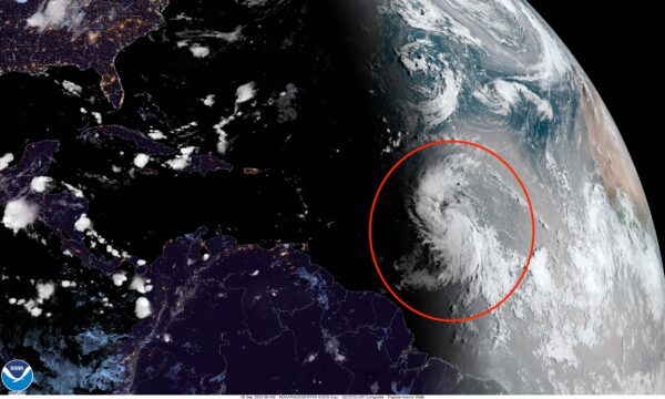
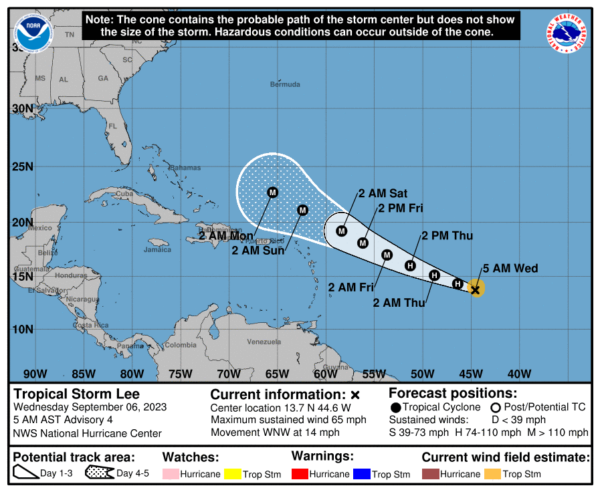
TROPICS: Tropical Storm Lee is in the Atlantic about halfway between the coast of Africa and the Lesser Antilles with winds of 65 mph. It will become a hurricane later today, and is expected to reach major hurricane strength (category three) tomorrow night. The latest NHC has it at category four strength with winds of 155 mph by the weekend passing north of the Leeward Islands and Puerto Rico.
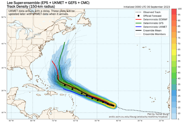
Ensemble output from global models continues to show a sharp turn to the north early next week, keeping Lee east of the Bahamas and the U.S. East Coast. It could impact the Canadian Maritimes by the end of next week, but it should be a much weaker system by then thanks to cooler water due to upwelling from Franklin.
Elsewhere, Invest 96L is in the far eastern Atlantic, and is expected to become Tropical Storm Margot over the next few days. It will turn north and is no threat to land.
No tropical storms or hurricanes will threaten the Gulf of Mexico for at least the next seven to ten days.
ON THIS DATE IN 1933: The remnant low of the Treasure Coast Hurricane dumped 10.33″ of rain in Charleston, which is the second-highest 24-hour rainfall total on record for the downtown station. The storm produced wind gusts of 51 mph and also spawned a tornado near the city.
ON THIS DATE IN 2017: Category 5 Hurricane Irma affected the US Virgin Island and Puerto Rico. Maximum sustained winds were at 180 mph when the storm hit St. Thomas & St. John. Catastrophic damage was reported over the US Virgin Island & significant damage over Puerto Rico, especially over Culebra.
Look for the next video briefing here by 3:00 this afternoon… enjoy the day!
Category: Alabama's Weather, ALL POSTS, Weather Xtreme Videos


