Mostly Dry Labor Day Weekend Ahead
**No video briefing this afternoon due to Friday Night Rivals football remotes**
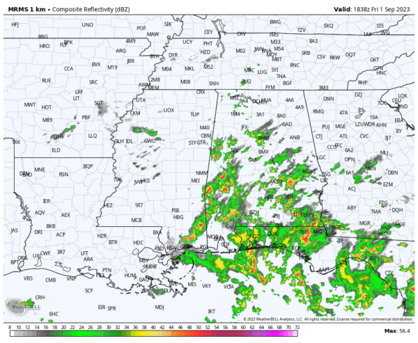
RADAR CHECK: Showers and thunderstorms continue to move northward across Alabama this afternoon thanks to an upper low spinning away over Louisiana. Temperatures are mostly in the 77-84 degree range with a mostly cloudy sky. Showers will fade tonight after sunset.
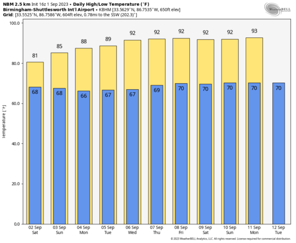
LABOR DAY WEEKEND: Tomorrow will feature mostly cloudy sky, and scattered showers remain possible over the southern 2/3 of the state (generally from I-20 south). Highs will be in the low to mid 80s, which is below average for early September in Alabama. Then, dry weather is the story for most of the state Sunday and Monday with a partly to mostly sunny sky and slowly rising heat levels. Highs will be in the 88-92 degree range.
REST OF NEXT WEEK: Most of the week looks dry with mostly sunny days, fair nights, and highs in the 90-94 degree range. A few scattered showers could up by Friday… See the video briefing for maps, graphics, and more details.
FOOTBALL WEATHER: For the high school games across Alabama tonight, a few scattered showers are possible, mainly during the first half of the games. Temperatures will fall through the 70s.
Tomorrow Jacksonville State hosts East Tennessee State (1:00 CT kickoff)… expect a mostly cloudy sky with temperatures around 80 degrees through the game. There is an outside risk of a passing shower.
Auburn will host UMass tomorrow afternoon at Jordan-Hare Stadium (2:30p CT kickoff)… the sky will be mostly cloudy; there is a small risk of a shower during the game. Expect a kickoff temperature near 82 degrees, falling to near 80 by the final whistle.
And, tomorrow evening Alabama hosts Middle Tennessee State at Bryant-Denny Stadium (6:30p CT kickoff). Expect a mostly cloudy sky with temperatures falling from near 81 degrees at kickoff through the upper 70s during the game.
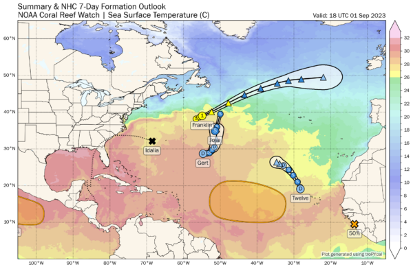
TROPICS: There is a cluster of tropical systems in the Atlantic, but none of them will impact the U.S. or the Gulf of Mexico for at least the next seven days.
*Idalia is now a post-tropical cyclone moving away from the U.S… it is expected to become a tropical storm again over the weekend with some impact to Bermuda tomorrow. From there is heads out to the North Atlantic.
*Franklin is still a hurricane with winds of 80 mph well northeast of Bermuda. It becomes post-tropical tonight as it heads to the North Atlantic.
*Jose is a junk tropical storm that will be absorbed by Franklin by tomorrow morning.
*Gert has regenerated; it is a tropical depression over the open Atlantic, and will be absorbed by Idalia by Sunday far from land.
*Tropical Depression Eleven has formed in the eastern Atlantic, and it will likely become a tropical storm over the weekend. It will turn north and will remain far from land.
ON THIS DATE IN 1974: Lt. Judy Neuffer became the first female to fly a Hurricane Hunter aircraft through the eye of a hurricane.
ON THIS DATE IN 2018: Hurricane Gustav made landfall over SE Louisiana at category two strength. Several parishes in the New Orleans area announced plans for voluntary evacuations beginning Saturday, August 30. New Orleans Mayor Ray Nagin said that it was possible thousands of people who need city help could start leaving on Saturday, as the first wave of a full-scale evacuation. Later, he ordered the mandatory evacuation of the whole of New Orleans commencing on the morning of August 31, calling Gustav “the storm of the century … the mother of all storms”.
Look for my next video briefing here by 6:00 a.m. Monday… enjoy the weekend!
Category: Alabama's Weather, ALL POSTS, Weather Xtreme Videos


