Midday Nowcast: Lower Heat Levels, Higher Rain Chances
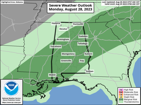
FINAL WEEK OF AUGUST: Average high for Birmingham this final week of August is 90° and we will be pretty close to that this week. The strong upper ridge is weakening and retrograding back to the west as evident by showers and storms on the radar this morning and more storms are expected this afternoon. The SPC has much of Alabama in a “marginal risk” (level 1/5) of severe thunderstorms today.
Storms this afternoon and early tonight will have potential for microbursts, small scale areas of damaging straight line winds. But also, storms will produce lots of lightning and tropical downpours which could lead to areas of isolated flash flooding.
Highs today will range from the upper 80s over North Alabama to the low to mid 90s over the southern counties of the state. A heat advisory is in effect today for the southern half of Alabama, but after today, even the southern parts of the state will be done with the heat alerts.
REST OF THE WEEK: We expect scattered to numerous showers and thunderstorms tomorrow; the sky will be cloudy at times with a highs in the mid to upper 80s. Then, on Wednesday, the best chance of rain will over the southeast part of the state (mainly from Montgomery south and east) as Hurricane Idalia passes through North Florida and South Georgia. Thursday and Friday will be dry with lower humidity and cooler nights; highs will be in the 80s for North Alabama, with low 90s to the south.
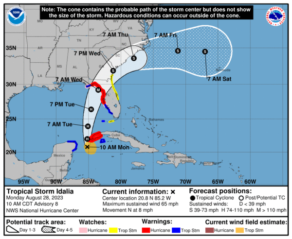
TROPICAL STORM IDALIA: Pronounced ee-DAL-ya, will soon become a hurricane and is forecast to intensify into a major hurricane (category 3 or greater) by the time it makes landfall between the Big Bend of Florida and Tampa along west coast of Florida Wednesday. Hurricane warnings are now in effect for these areas.
Latest update from NHC: The center of Tropical Storm Idalia was located near latitude 20.8 North, longitude 85.2 West. Idalia is moving toward the north near 8 mph. A northward motion is expected through tonight, followed by a faster north-northeast motion on Tuesday and Wednesday. On the forecast track, the center of Idalia is forecast to pass near or over western Cuba tonight, over the extreme southeastern Gulf of Mexico by early Tuesday, and reach the Gulf coast of Florida on Wednesday.
Maximum sustained winds are near 65 mph with higher gusts. Idalia is forecast to become a hurricane later today and a dangerous major hurricane over the northeastern Gulf of Mexico by early Wednesday. Tropical-storm-force winds extend outward up to 105 miles from the center. The latest minimum central pressure estimated from data from an Air Force Reserve reconnaissance aircraft is 990 mb (29.24 inches).
In the eastern Gulf, very favorable conditions for rapid intensification will be in place and why intensity forecast continue to increase. The risk continues to increase for life-threatening storm surge and dangerous hurricane-force winds along portions of the west coast of Florida beginning as early as late tomorrow.
Remember, the main impact from wind, rain, storm surge, flooding, and isolated tornadoes will be along and to the right (south down the west coast of the Florida Peninsula) of the circulation center.
The Alabama Gulf Coast and the western part of the Florida Panhandle won’t have much direct impact from Idalia in terms of weather, but dangerous rip currents are likely tomorrow and Wednesday. Alabama will be on the dry side of the system, but a few showers and breezy conditions are likely over the southeast counties of the state Wednesday, but overall, little to no impacts from Idalia are expected for Alabama.
LABOR DAY WEEKEND: Most of Alabama will be dry… expect mostly sunny days and fair nights with highs in the upper 80s and low 90s for most communities. We can’t rule out a few isolated showers Saturday over the far southern part of the state, but even there most places will be dry.
INTO NEXT WEEK: The upper ridge begins to rebuild; highs will be in the 90-95 degree range with only isolated afternoon showers or storms around.
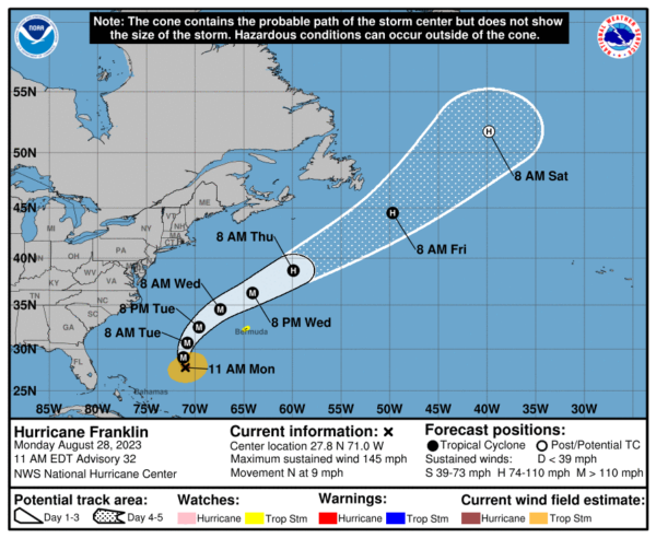
ELSEWHERE IN THE TROPICS: Hurricane Franklin in now a major hurricane with winds of 145 mph and it should continue to intensify. It should avoid land, but will graze Bermuda as it moves north between the East Coast and Bermuda, then it will be picked up by the westerlies and rapidly be pushed off into North Atlantic where it will dissipate.
BEACH FORECAST CENTER: Get the latest weather and rip current forecasts for the beaches from Fort Morgan to Panama City on our Beach Forecast Center page. There, you can select the forecast of the region that you are interested in visiting.
WORLD TEMPERATURE EXTREMES: Over the last 24 hours, the highest observation outside the U.S. was 125.6F at Hurguada, Egypt. The lowest observation was -103.0F Vostok, Antarctica.
CONTIGUOUS TEMPERATURE EXTREMES: Over the last 24 hours, the highest observation was 118F at Winterhaven, CA. The lowest observation was 27F at Watton, MI.
Category: Alabama's Weather, ALL POSTS


