Sunday Weather Briefing — Another Steamer with Strong Storms Possible
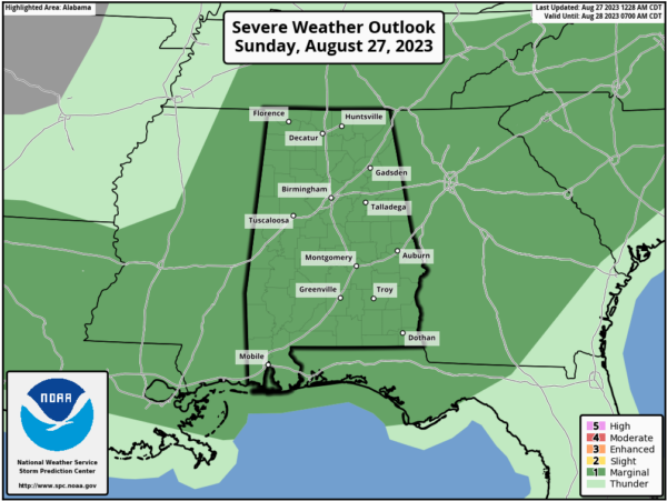
A surface front moves into the area today, and with a short wave moving along the boundary, we’ll have a setup for scattered to numerous showers and storms, some of which may be strong to severe. The entire state has been placed in a Marginal Risk with damaging winds and hail up to quarter size being the threats. Afternoon highs will be in the lower 90s to the lower 100s across the area, and all of Central Alabama is under a Heat Advisory.
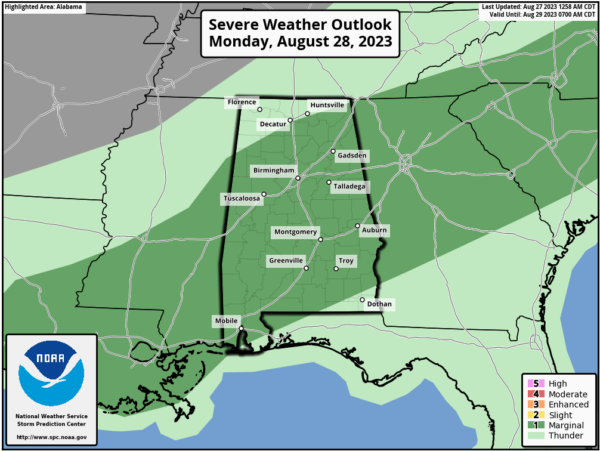
Monday’s weather won’t be much different than today’s, but temperatures may be held back just a little. The surface front will continue to hang out over Central Alabama, and we’ll continue to have a Marginal Risk for severe storms for nearly all of Central Alabama. Showers and storms will once again fire up during the main heating of the day and persist into the evening. Damaging winds and quarter-size hail will be possible with any severe storm. Highs in the mid 80s to the mid 90s.
The stalled front will continue to bring a good chance of scattered showers and storms to the area on Tuesday, mainly in the afternoon and evening hours. For now, there is not a risk of severe storms as the ingredients will not be as high as today or Monday. Highs in the lower 80s to the lower 90s.
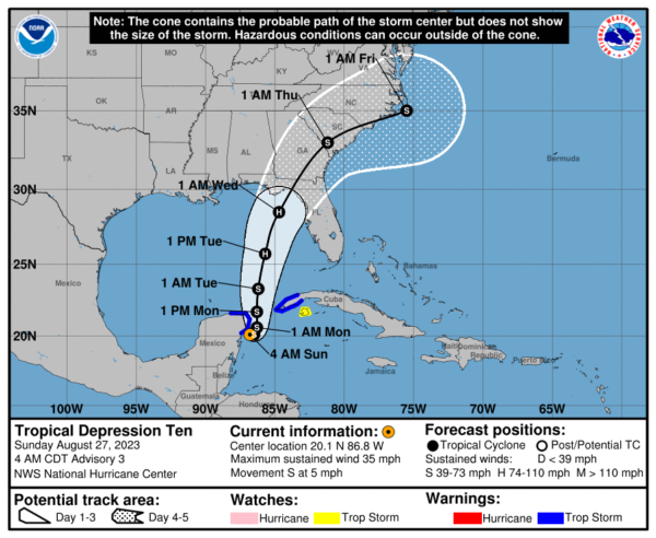
The tropical system will make landfall along the Florida Panhandle and eventually move up into southern Georgia on Wednesday. While we will be on the good side of the system, we can’t rule out a little bit of a breeze with scattered showers. Most of the activity will be over the southeast quarter of Central Alabama. Highs in the 80s.
We’ll have a northerly flow from the backside of the system on Thursday that will bring us much drier weather with highs in the lower 80s to the lower 90s.
Ridging will start to build back in for Friday and into the weekend that will keep us dry with plenty of sunshine. Humidity will be lower, so it will be comfortable outdoors with highs in the mid 80s to the lower 90s.
And at the end of the forecast period on Saturday, it will be almost a copy of Friday’s weather, but it will be a touch warmer. Highs in the upper 80s to the lower 90s.
Tropical Depression #10 continues to meander around very close to Cozumel with maximum sustained winds around 35 mph. It will eventually begin to move to the north or north-northeast on Monday. For now, wind shear will keep development slow for the next day or so, but the shear will diminish and there is a great possibility for rapid intensification over the Gulf of Mexico. Latest projections have it reaching 90 mph for maximum wind speeds, but that could be under what may actually occur. Projected landfall looks to be around the Big Bend area of the Florida Peninsula on Wednesday morning as a hurricane and will move quickly off to the northeast and back out over the Atlantic Ocean. TD-10 will become a tropical storm later today.
Category: Alabama's Weather, ALL POSTS, Severe Weather, Tropical, Weather Xtreme Videos


