TD 10 Update: Tropical Storm Formation Likely on Sunday
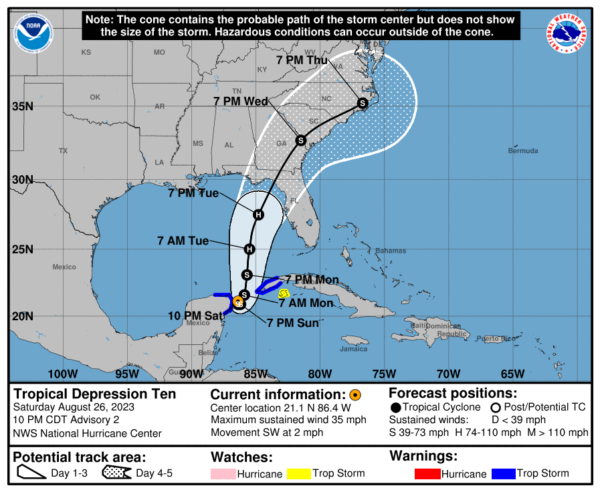
We are looking at the depression strengthening during the next few days and could become a hurricane over the eastern Gulf of Mexico, bringing a potential of dangerous storm surge, heavy rainfall, and strong winds to portions of the west coast of Florida and the Florida Panhandle by the middle of next week. The track has shifted ever so slightly to the east, but don’t be surprised if it moves back and forth throughout the entire event.
…DEPRESSION EXPECTED TO BECOME A TROPICAL STORM ON SUNDAY…
…LIKELY TO BECOME A HURRICANE OVER THE EASTERN GULF OF MEXICO IN A FEW DAYS…
SUMMARY OF 1000 PM CDT…0300 UTC…INFORMATION
———————————————–
LOCATION…21.1N 86.4W
ABOUT 55 MI…85 KM NE OF COZUMEL MEXICO
MAXIMUM SUSTAINED WINDS…35 MPH…55 KM/H
PRESENT MOVEMENT…SW OR 230 DEGREES AT 2 MPH…4 KM/H
MINIMUM CENTRAL PRESSURE…1005 MB…29.68 INCHES
WATCHES AND WARNINGS
——————–
A Tropical Storm Warning is in effect for…
* Yucatán Peninsula from Tulum to Rio Lagartos, including Cozumel
* Pinar del Rio Cuba
A Tropical Storm Watch is in effect for…
* Isle of Youth Cuba
DISCUSSION AND OUTLOOK
———————-
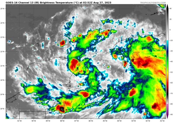
At 1000 PM CDT (0300 UTC), the center of Tropical Depression Ten was located near latitude 21.1 North, longitude 86.4 West. The depression is drifting toward the southwest near 2 mph (4 km/h) and is likely to meander near the Yucatán Channel through early Monday. A faster motion toward the north or north-northeast is expected on Monday, bringing the system over the eastern Gulf of Mexico. Maximum sustained winds are near 35 mph (55 km/h) with higher gusts. Additional strengthening is forecast during the next few days. The depression is expected to become a tropical storm on Sunday and a hurricane by Tuesday. The estimated minimum central pressure is 1005 mb (29.68 inches).
HAZARDS AFFECTING LAND
———————-
RAINFALL: Tropical Depression Ten is expected to produce rainfall amounts of 3 to 6 inches, with isolated higher amounts of 10 inches, across portions of the eastern Yucatán Peninsula. Across western Cuba, rainfall amounts of 4 to 8 inches, with isolated maximum amounts of 12 inches, are expected. This rainfall may lead to flash and urban flooding, and landslides across western Cuba. Heavy rainfall is also likely to impact portions of the west coast of Florida, the Florida Panhandle, and the Southeast by mid to late next week.
WIND: Tropical storm conditions are expected to begin over portions of the warning area over the Yucatán Peninsula on Sunday and western Cuba Sunday night or Monday. Tropical storm conditions are possible within the watch area on the Isle of Youth Sunday night or Monday.
STORM SURGE: Minor coastal flooding is expected within the Tropical Storm Warning area over the Yucatán Peninsula in areas of onshore winds.
Category: Alabama's Weather, ALL POSTS, Tropical


