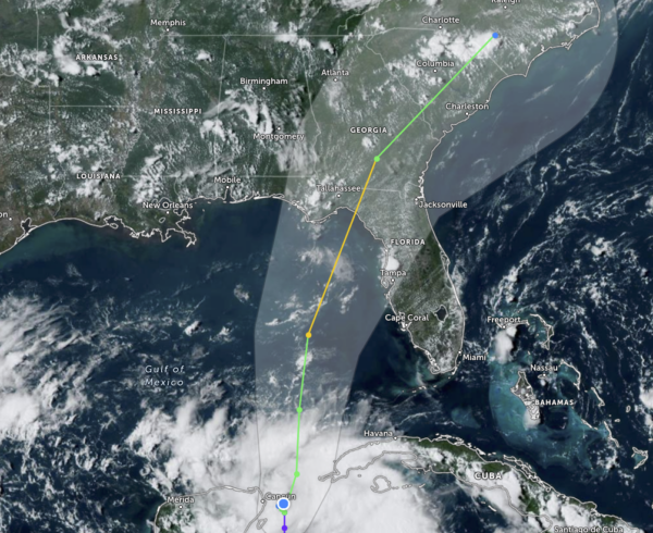
Invest 93L Has Now Become Tropical Depression #10
It has happened… Invest 93L has become better organized and the National Hurricane Center now classifies the system as a tropical depression. We also note that they have it strengthening into a category one hurricane before making landfall on the Gulf Coast of Florida. Here are the key messages and the 4 pm update:
1. Heavy rainfall from Tropical Depression Ten is expected across the eastern Yucatán Peninsula and western Cuba. The heavy rainfall may produce areas of flash and urban flooding, as well as landslides, across western Cuba. The depression is forecast to become a tropical storm by Sunday, and tropical storm conditions are expected over portions of the Yucatán Peninsula where a Tropical Storm Warning is in effect. Tropical storm conditions are possible over portions of western Cuba within the Tropical Storm Watch area.
2. The depression is forecast to strengthen during the next few days and could become a hurricane over the eastern Gulf of Mexico, bringing a potential of dangerous storm surge, heavy rainfall, and strong winds to portions of the west coast of Florida and the Florida Panhandle by the middle of next week. Heavy rainfall is also likely to spread into portions of the Southeast U.S. by mid to late next week. Although it is too soon to specify the exact location and magnitude of these impacts, residents in these areas should monitor updates to the forecast of this system and ensure that they have their hurricane plan in place.
SUMMARY OF 400 PM CDT…2100 UTC…INFORMATION
———————————————-
LOCATION…21.1N 86.1W
ABOUT 65 MI…105 KM NE OF COZUMEL MEXICO
MAXIMUM SUSTAINED WINDS…30 MPH…45 KM/H
PRESENT MOVEMENT…STATIONARY
MINIMUM CENTRAL PRESSURE…1006 MB…29.71 INCHES
WATCHES AND WARNINGS
——————–
SUMMARY OF WATCHES AND WARNINGS IN EFFECT:
A Tropical Storm Warning is in effect for…
* Yucatán Peninsula from Tulum to Rio Lagartos, including Cozumel
A Tropical Storm Watch is in effect for…
* Pinar del Rio and the Isle of Youth
DISCUSSION AND OUTLOOK
———————-
At 400 PM CDT (2100 UTC), the center of Tropical Depression Ten was located near latitude 21.1 North, longitude 86.2 West. The depression is nearly stationary, and little overall movement is expected through Sunday. A slow, generally northward, motion is expected to begin on Monday. On the forecast track, the center will move into the southeastern Gulf of Mexico by Monday. Maximum sustained winds are near 30 mph (45 km/h) with higher gusts. Gradual strengthening is forecast during the next 48 hours, and the system is likely to become a tropical storm on Sunday. The estimated minimum central pressure is 1006 mb (29.71 inches).
HAZARDS AFFECTING LAND
———————-
RAINFALL: Tropical Depression Ten is expected to produce rainfall amounts of 3 to 6 inches, with isolated higher amounts of 10 inches, across portions of the eastern Yucatán Peninsula. Across western Cuba, rainfall amounts of 4 to 8 inches, with isolated maximum amounts of 12 inches, are expected. This rainfall may lead to flash and urban flooding, and landslides across western Cuba. Heavy rainfall is also likely to impact portions of the Gulf Coast and portions of the Southeast by mid- to late next week.
WIND: Tropical storm conditions are expected to begin over portions of the warning area over the Yucatán Peninsula on Sunday. Tropical storm conditions are possible within the watch area over western Cuba beginning on Sunday.
STORM SURGE: Minor coastal flooding is expected within the Tropical Storm Warning area over the Yucatán Peninsula in areas of onshore winds.
Category: Alabama's Weather, ALL POSTS, Tropical


